
Magnitude |
:3 |
| Date & Time (UTC) | 2011-07-24 17:43:55.9 |
| Date & Time (Local) | 1390/5/2 22:13:55.9 |
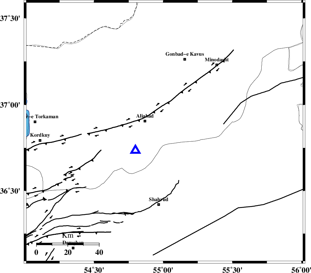
| Location | Lat:36.84 Lon: 55.01 |
| Region | Golestan Province, 14 km East of Ali Abad |
Nearest Cities |
|
| 15 km East of Ali Abad, Golestan Province | |
| 19 km South of Khanbebin, Golestan Province | |
| 22 km South of Deland, Golestan Province | |
| 23 km South West of Ramian, Golestan Province | |
| 24 km North of Qaleh-ye nokharqan, Semnan Province | |
| Depth | 14 km |
| Agency | |
Faults within 150 km: |
|
| SHAVAR_F (Length: 87 km) , Distance to epicenter: 16 km | |
| KHAZAR_F (Length: 523 km) , Distance to epicenter: 19 km | |
| ROBATE_QARABIL_F (Length: 168 km) , Distance to epicenter: 38 km | |
| Number of Phases | 6 |
| RMS | 0 |
| Number of Stations | 5 |
| Error in Latitude | >1.2 km |
| Error in Longitude | 2.2 km |
| Error in Depth | 3.3 km |
Download waveform in seisan format
to download seisan software Click here
to access information about IIEES stations Click here
Amplitude | ||||||||
| UID | Agency | Station | Component | Amplitude | Period | Arrival Time | Proccessing Time | Signal Clip |
| 79787 | IIEES | THKV | E | 27.9 | 0.6 | 2011-07-24 17:45:52 | 2011-07-24 07:02:00 | n |
| 79788 | IIEES | THKV | N | 28.6 | 0.56 | 2011-07-24 17:45:58 | 2011-07-24 07:02:00 | n |
Phase | ||||||||||||
| Agency | Station | Component | Phase Type | Phase Quality | First Motion | Observed Arrival Time | Time Residual | Loc. Flag | Input Weight | Distance | Azimuth | |
| IIEES | SHRO | Z | Pg | E | 2011-07-24 17:44:17 | -0.03 | y | 129 | 135 | |||
| IIEES | SHRO | N | Sg | E | 2011-07-24 17:44:33 | 0.04 | y | 129 | 135 | |||
| IIEES | MRVT | Z | Pg | E | 2011-07-24 17:44:17 | -0.02 | y | 132 | 46 | |||
| IIEES | BJRD | Z | Pn | E | 2011-07-24 17:44:32 | 0.04 | y | 233 | 65 | |||
| IIEES | THKV | Z | Pn | E | 2011-07-24 17:44:51 | 0.04 | y | 384 | 256 | |||
| IIEES | TABS | Z | P | E | 2011-07-24 17:44:53 | -0.08 | y | 403 | 151 | |||