
Magnitude |
:2.5 |
| Date & Time (UTC) | 2011-07-21 17:02:10.7 |
| Date & Time (Local) | 1390/4/30 21:32:10.7 |
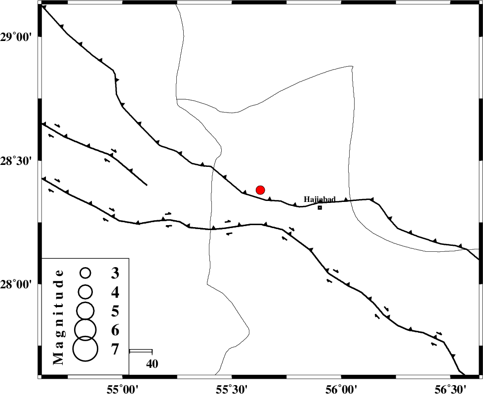
| Location | Lat:28.38 Lon: 55.63 |
| Region | Hormozgan Province, 27 km West of Hajiabad |
Nearest Cities |
|
| 28 km North West of Hajiabad, Hormozgan Province | |
| 35 km South East of Tal bargah, Fars Province | |
| 42 km North East of Doborji, Fars Province | |
| 48 km North East of Fadami, Fars Province | |
| 55 km East of Rostaq, Fars Province | |
| Depth | 16 km |
| Agency | |
Faults within 150 km: |
|
| MAIN_ZAGROS_R_F (Length: 1106 km) , Distance to epicenter: 5 km | |
| HZF2 (Length: 437 km) , Distance to epicenter: 15 km | |
| HZF1 (Length: 102 km) , Distance to epicenter: 51 km | |
| Number of Phases | 5 |
| RMS | 0.2 |
| Number of Stations | 3 |
| Error in Latitude | >1.8 km |
| Error in Longitude | 5.3 km |
| Error in Depth | 9 km |
Download waveform in seisan format
to download seisan software Click here
to access information about IIEES stations Click here
Amplitude | ||||||||
| UID | Agency | Station | Component | Amplitude | Period | Arrival Time | Proccessing Time | Signal Clip |
| 79727 | IIEES | BNDS | E | 112.7 | 0.44 | 2011-07-21 17:02:49 | 2011-07-21 05:18:00 | n |
| 79728 | IIEES | BNDS | N | 120.6 | 0.44 | 2011-07-21 17:02:53 | 2011-07-21 05:18:00 | n |
| 79729 | IIEES | KRBR | E | 43.2 | 0.56 | 2011-07-21 17:03:14 | 2011-07-21 05:18:00 | n |
| 79730 | IIEES | KRBR | N | 46.3 | 0.28 | 2011-07-21 17:03:17 | 2011-07-21 05:18:00 | n |
| 79731 | IIEES | GHIR | E | 22.2 | 0.44 | 2011-07-21 17:03:35 | 2011-07-21 05:18:00 | n |
| 79732 | IIEES | GHIR | N | 26.4 | 0.44 | 2011-07-21 17:03:41 | 2011-07-21 05:18:00 | n |
Phase | ||||||||||||
| Agency | Station | Component | Phase Type | Phase Quality | First Motion | Observed Arrival Time | Time Residual | Loc. Flag | Input Weight | Distance | Azimuth | |
| IIEES | BNDS | Z | Pg | E | 2011-07-21 17:02:30 | -0.36 | y | 121 | 154 | |||
| IIEES | BNDS | E | Sg | E | 2011-07-21 17:02:46 | 0.25 | y | 121 | 154 | |||
| IIEES | KRBR | Z | Pn | E | 2011-07-21 17:02:44 | -0.1 | y | 209 | 31 | |||
| IIEES | KRBR | N | Sg | E | 2011-07-21 17:03:10 | 0.1 | y | 209 | 31 | |||
| IIEES | GHIR | N | Pn | E | 2011-07-21 17:02:50 | 0.11 | y | 260 | 268 | |||