
Magnitude |
:3 |
| Date & Time (UTC) | 2011-07-10 06:36:37.2 |
| Date & Time (Local) | 1390/4/19 11:06:37.2 |
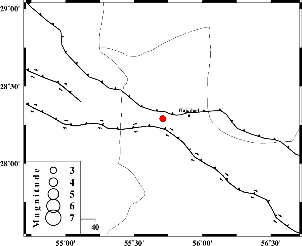
| Location | Lat:28.29 Lon: 55.71 |
| Region | Hormozgan Province, 19 km West of Hajiabad |
Nearest Cities |
|
| 19 km West of Hajiabad, Hormozgan Province | |
| 48 km South East of Tal bargah, Fars Province | |
| 50 km East of Doborji, Fars Province | |
| 52 km North East of Fadami, Fars Province | |
| 55 km North East of Darz, Fars Province | |
| Depth | 42 km |
| Agency | |
Faults within 150 km: |
|
| MAIN_ZAGROS_R_F (Length: 1106 km) , Distance to epicenter: 5 km | |
| HZF2 (Length: 437 km) , Distance to epicenter: 8 km | |
| HZF1 (Length: 102 km) , Distance to epicenter: 60 km | |
| Number of Phases | 5 |
| RMS | 0.1 |
| Number of Stations | 4 |
| Error in Latitude | >1.7 km |
| Error in Longitude | 3.8 km |
| Error in Depth | 4.4 km |
Download waveform in seisan format
to download seisan software Click here
to access information about IIEES stations Click here
Amplitude | ||||||||
| UID | Agency | Station | Component | Amplitude | Period | Arrival Time | Proccessing Time | Signal Clip |
| 79633 | IIEES | BNDS | E | 386 | 0.41 | 2011-07-10 06:37:16 | 2011-07-10 06:51:00 | n |
| 79634 | IIEES | KRBR | N | 134.1 | 0.36 | 2011-07-10 06:37:41 | 2011-07-10 06:51:00 | n |
| 79635 | IIEES | KRBR | E | 122.1 | 0.23 | 2011-07-10 06:37:43 | 2011-07-10 06:51:00 | n |
| 79636 | IIEES | GHIR | E | 65.3 | 0.47 | 2011-07-10 06:38:04 | 2011-07-10 06:51:00 | n |
Phase | ||||||||||||
| Agency | Station | Component | Phase Type | Phase Quality | First Motion | Observed Arrival Time | Time Residual | Loc. Flag | Input Weight | Distance | Azimuth | |
| IIEES | BNDS | Z | Pg | E | 2011-07-10 06:36:55 | -0.03 | y | 109 | 155 | |||
| IIEES | KRBR | Z | Pn | E | 2011-07-10 06:37:09 | 0.03 | y | 214 | 28 | |||
| IIEES | KRBR | E | Sg | E | 2011-07-10 06:37:37 | 0.03 | y | 214 | 28 | |||
| IIEES | GHIR | Z | Pn | E | 2011-07-10 06:37:15 | 0.09 | y | 267 | 271 | |||
| IIEES | NASN | Z | Pn | E | 2011-07-10 06:37:53 | -0.22 | y | 572 | 332 | |||