
Magnitude |
:3.5 |
| Date & Time (UTC) | 2011-07-10 06:20:01.9 |
| Date & Time (Local) | 1390/4/19 10:50:01.9 |
| Location | Lat:28.36 Lon: 55.66 |
| Region | Hormozgan Province, 24 km West of Hajiabad |
Nearest Cities |
|
| 24 km North West of Hajiabad, Hormozgan Province | |
| 39 km South East of Tal bargah, Fars Province | |
| 45 km North East of Doborji, Fars Province | |
| 50 km North East of Fadami, Fars Province | |
| 58 km East of Rostaq, Fars Province | |
| Depth | 18 km |
| Agency | |
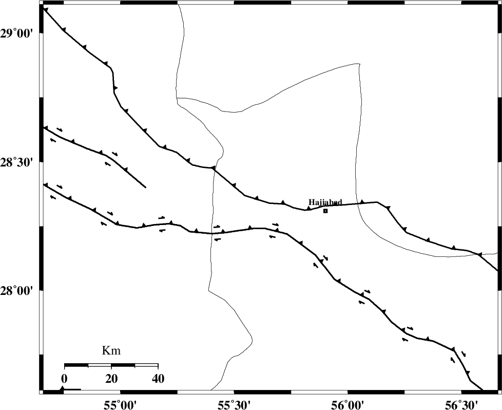
Faults within 150 km: |
|
| MAIN_ZAGROS_R_F (Length: 1106 km) , Distance to epicenter: 2 km | |
| HZF2 (Length: 437 km) , Distance to epicenter: 13 km | |
| HZF1 (Length: 102 km) , Distance to epicenter: 54 km | |
| Number of Phases | 6 |
| RMS | 0.1 |
| Number of Stations | 5 |
| Error in Latitude | >1.5 km |
| Error in Longitude | 3.3 km |
| Error in Depth | 4.9 km |
Download waveform in seisan format
to download seisan software Click here
to access information about IIEES stations Click here
Amplitude | ||||||||
| UID | Agency | Station | Component | Amplitude | Period | Arrival Time | Proccessing Time | Signal Clip |
| 79628 | IIEES | BNDS | E | 1292.4 | 0.47 | 2011-07-10 06:20:40 | 2011-07-10 06:37:00 | n |
| 79629 | IIEES | KRBR | N | 489.8 | 0.54 | 2011-07-10 06:21:07 | 2011-07-10 06:37:00 | n |
| 79630 | IIEES | KRBR | E | 339.4 | 0.29 | 2011-07-10 06:21:09 | 2011-07-10 06:37:00 | n |
| 79631 | IIEES | GHIR | E | 214.3 | 0.64 | 2011-07-10 06:21:34 | 2011-07-10 06:37:00 | n |
| 79632 | IIEES | GHIR | N | 305.5 | 0.54 | 2011-07-10 06:21:37 | 2011-07-10 06:37:00 | n |
Phase | ||||||||||||
| Agency | Station | Component | Phase Type | Phase Quality | First Motion | Observed Arrival Time | Time Residual | Loc. Flag | Input Weight | Distance | Azimuth | |
| IIEES | BNDS | Z | Pg | E | 2011-07-10 06:20:21 | 0.02 | y | 118 | 155 | |||
| IIEES | KRBR | Z | Pn | E | 2011-07-10 06:20:35 | -0.1 | y | 209 | 30 | |||
| IIEES | KRBR | N | Sg | E | 2011-07-10 06:21:01 | -0.02 | y | 209 | 30 | |||
| IIEES | GHIR | Z | Pn | E | 2011-07-10 06:20:41 | -0.05 | y | 263 | 269 | |||
| IIEES | NASN | Z | Pn | E | 2011-07-10 06:21:19 | 0.05 | y | 563 | 332 | |||
| IIEES | TABS | Z | Pn | E | 2011-07-10 06:21:24 | 0.22 | y | 603 | 13 | |||