
Magnitude |
:2.5 |
| Date & Time (UTC) | 2011-07-05 16:03:49.8 |
| Date & Time (Local) | 1390/4/14 20:33:49.8 |
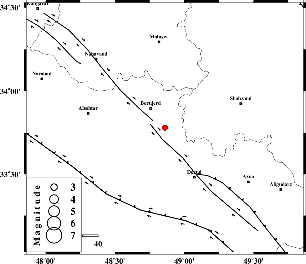
| Location | Lat:33.78 Lon: 48.86 |
| Region | Lorestan Province, 16 km South of Borujerd |
Nearest Cities |
|
| 9 km of Hemmatabad, Lorestan Province | |
| 9 km of Valanjerd, Lorestan Province | |
| 13 km North of Chalanchulan, Lorestan Province | |
| 16 km South East of Borujerd, Lorestan Province | |
| 19 km West of Hashian, Markazi Province | |
| Depth | 14 km |
| Agency | |
Faults within 150 km: |
|
| DORUD (Length: 100 km) , Distance to epicenter: 8 km | |
| NAHAVAND_F (Length: 102 km) , Distance to epicenter: 9 km | |
| MAIN_ZAGROS_R_F (Length: 1106 km) , Distance to epicenter: 38 km | |
| Number of Phases | 5 |
| RMS | 0.1 |
| Number of Stations | 4 |
| Error in Latitude | >2.5 km |
| Error in Longitude | 1.5 km |
| Error in Depth | 4.6 km |
Download waveform in seisan format
to download seisan software Click here
to access information about IIEES stations Click here
Amplitude | ||||||||
| UID | Agency | Station | Component | Amplitude | Period | Arrival Time | Proccessing Time | Signal Clip |
| 79548 | IIEES | SNGE | N | 46.1 | 0.4 | 2011-07-05 16:04:53 | 2011-07-05 04:32:00 | n |
| 79549 | IIEES | SNGE | E | 38.9 | 0.52 | 2011-07-05 16:04:53 | 2011-07-05 04:32:00 | n |
| 79550 | IIEES | GHVR | N | 33 | 0.48 | 2011-07-05 16:05:05 | 2011-07-05 04:32:00 | n |
| 79551 | IIEES | GHVR | E | 38.5 | 0.36 | 2011-07-05 16:05:07 | 2011-07-05 04:32:00 | n |
Phase | ||||||||||||
| Agency | Station | Component | Phase Type | Phase Quality | First Motion | Observed Arrival Time | Time Residual | Loc. Flag | Input Weight | Distance | Azimuth | |
| IIEES | KHMZ | Z | Pg | E | 2011-07-05 16:04:07 | -0.06 | y | 103 | 92 | |||
| IIEES | ASAO | Z | Pg | E | 2011-07-05 16:04:12 | 0.03 | y | 138 | 51 | |||
| IIEES | ASAO | N | Sg | E | 2011-07-05 16:04:29 | 0.01 | y | 138 | 51 | |||
| IIEES | SNGE | Z | Pn | E | 2011-07-05 16:04:22 | 0.09 | y | 201 | 317 | |||
| IIEES | SNGE | E | Sg | E | 2011-07-05 16:04:47 | -0.07 | y | 201 | 317 | |||