
Magnitude |
:3.2 |
| Date & Time (UTC) | 2011-06-30 02:38:31.9 |
| Date & Time (Local) | 1390/4/9 07:08:31.9 |
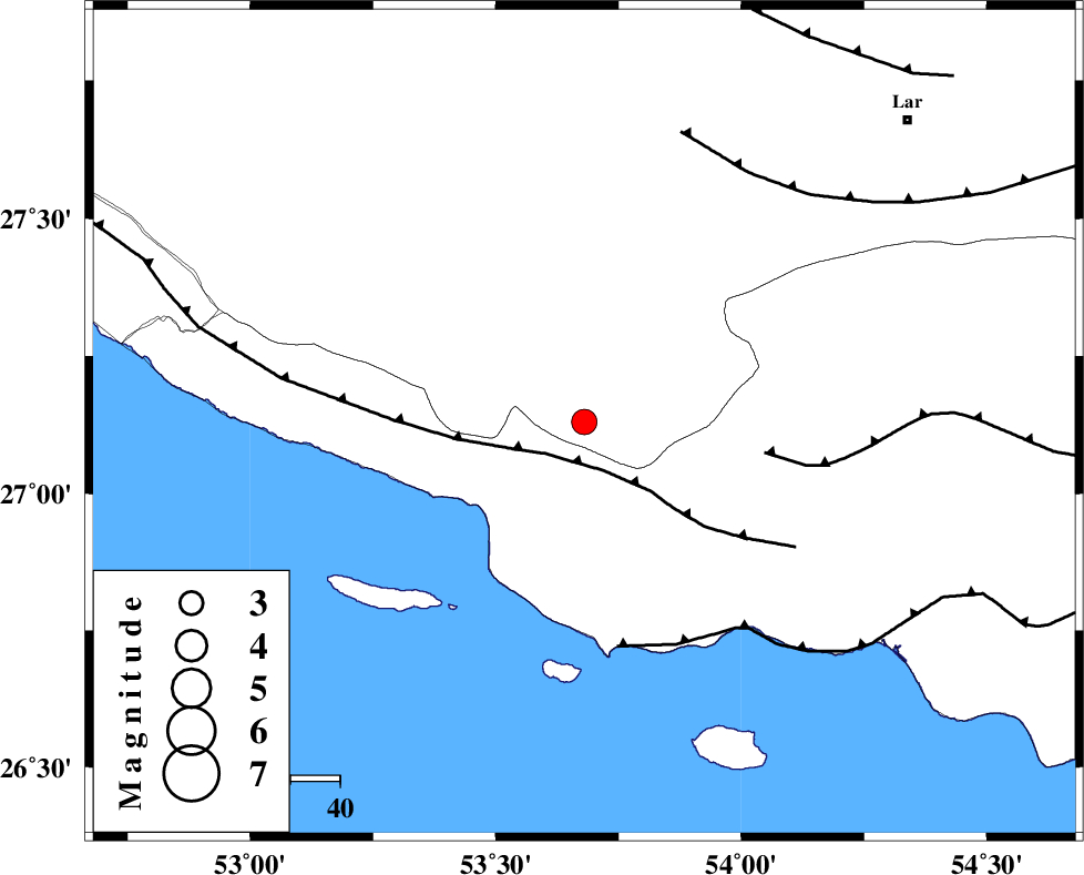
| Location | Lat:27.13 Lon: 53.68 |
| Region | Fars Province, 55 km South-East of Lamerd |
Nearest Cities |
|
| 7 km of Ahl, Fars Province | |
| 12 km of Ashkenan, Fars Province | |
| 37 km South East of Beyram, Fars Province | |
| 53 km South East of Fedagh, Fars Province | |
| 54 km South West of Bagh, Fars Province | |
| Depth | 14 km |
| Agency | |
Faults within 150 km: |
|
| MFF3 (Length: 292 km) , Distance to epicenter: 8 km | |
| MFF1 (Length: 180 km) , Distance to epicenter: 37 km | |
| ZFF1 (Length: 165 km) , Distance to epicenter: 46 km | |
| Number of Phases | 5 |
| RMS | 0.1 |
| Number of Stations | 3 |
| Error in Latitude | >5.8 km |
| Error in Longitude | 3.3 km |
| Error in Depth | 5.1 km |
Download waveform in seisan format
to download seisan software Click here
to access information about IIEES stations Click here
Amplitude | ||||||||
| UID | Agency | Station | Component | Amplitude | Period | Arrival Time | Proccessing Time | Signal Clip |
| 79474 | IIEES | GHIR | N | 379.2 | 0.6 | 2011-06-30 02:39:15 | 2011-06-30 02:49:00 | n |
| 79475 | IIEES | GHIR | E | 451.9 | 0.36 | 2011-06-30 02:39:15 | 2011-06-30 02:49:00 | n |
| 79476 | IIEES | BNDS | N | 96.7 | 0.4 | 2011-06-30 02:39:50 | 2011-06-30 02:49:00 | n |
| 79477 | IIEES | BNDS | E | 113.2 | 0.44 | 2011-06-30 02:39:53 | 2011-06-30 02:49:00 | n |
| 79478 | IIEES | KRBR | N | 32.2 | 0.56 | 2011-06-30 02:40:46 | 2011-06-30 02:49:00 | n |
| 79479 | IIEES | KRBR | E | 33.8 | 0.68 | 2011-06-30 02:40:51 | 2011-06-30 02:49:00 | n |
Phase | ||||||||||||
| Agency | Station | Component | Phase Type | Phase Quality | First Motion | Observed Arrival Time | Time Residual | Loc. Flag | Input Weight | Distance | Azimuth | |
| IIEES | GHIR | Z | Pg | E | 2011-06-30 02:38:56 | -0.1 | y | 145 | 332 | |||
| IIEES | GHIR | N | Sg | E | 2011-06-30 02:39:13 | 0 | y | 145 | 332 | |||
| IIEES | BNDS | Z | Pn | E | 2011-06-30 02:39:10 | 0 | y | 249 | 83 | |||
| IIEES | BNDS | N | Sg | E | 2011-06-30 02:39:42 | -0.1 | y | 249 | 83 | |||
| IIEES | KRBR | Z | Pn | E | 2011-06-30 02:39:34 | 0.1 | y | 437 | 43 | |||