
Magnitude |
:2.6 |
| Date & Time (UTC) | 2011-06-28 22:59:00.3 |
| Date & Time (Local) | 1390/4/8 03:29:00.3 |
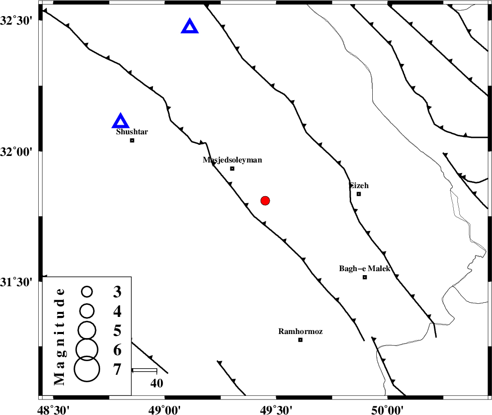
| Location | Lat:31.81 Lon: 49.45 |
| Region | Khoozestan Province, 20 km South-East of Masjed Soleyman |
Nearest Cities |
|
| 20 km South East of Masjed Soleyman, Khoozestan Province | |
| 29 km North of Gazin, Khoozestan Province | |
| 30 km North of Jaru, Khoozestan Province | |
| 31 km North West of Chenarestan, Khoozestan Province | |
| 35 km West of Rasvand, Khoozestan Province | |
| Depth | 14 km |
| Agency | |
Faults within 150 km: |
|
| DEZFUL_EMBAYMENT (Length: 228 km) , Distance to epicenter: 8 km | |
| MFF2 (Length: 205 km) , Distance to epicenter: 33 km | |
| AGHAJARI_F (Length: 88 km) , Distance to epicenter: 71 km | |
| Number of Phases | 4 |
| RMS | 0.3 |
| Number of Stations | 4 |
| Error in Latitude | >13.5 km |
| Error in Longitude | 8.8 km |
| Error in Depth | 15.2 km |
Download waveform in seisan format
to download seisan software Click here
to access information about IIEES stations Click here
Amplitude | ||||||||
| UID | Agency | Station | Component | Amplitude | Period | Arrival Time | Proccessing Time | Signal Clip |
| 79452 | IIEES | SHGR | N | 295 | 1.22 | 2011-06-28 22:59:26 | 2011-06-28 11:22:00 | n |
| 79453 | IIEES | SHGR | E | 293.2 | 0.3 | 2011-06-28 22:59:31 | 2011-06-28 11:22:00 | n |
| 79454 | IIEES | KHMZ | N | 40.7 | 0.85 | 2011-06-28 23:00:10 | 2011-06-28 11:22:00 | n |
| 79455 | IIEES | NASN | E | 16.1 | 1.59 | 2011-06-28 23:00:46 | 2011-06-28 11:22:00 | n |
Phase | ||||||||||||
| Agency | Station | Component | Phase Type | Phase Quality | First Motion | Observed Arrival Time | Time Residual | Loc. Flag | Input Weight | Distance | Azimuth | |
| IIEES | SHGR | Z | Pg | E | 2011-06-28 22:59:12 | -0.1 | y | 69.8 | 299 | |||
| IIEES | KHMZ | Z | Pg | E | 2011-06-28 22:59:36 | -0.3 | y | 220 | 13 | |||
| IIEES | ASAO | Z | Pn | E | 2011-06-28 22:59:47 | 0.5 | y | 309 | 10 | |||
| IIEES | NASN | Z | Pn | E | 2011-06-28 22:59:49 | -0.1 | y | 335 | 70 | |||