
Magnitude |
:3.4 |
| Date & Time (UTC) | 2011-06-15 04:39:47.0 |
| Date & Time (Local) | 1390/3/25 09:09:47.0 |
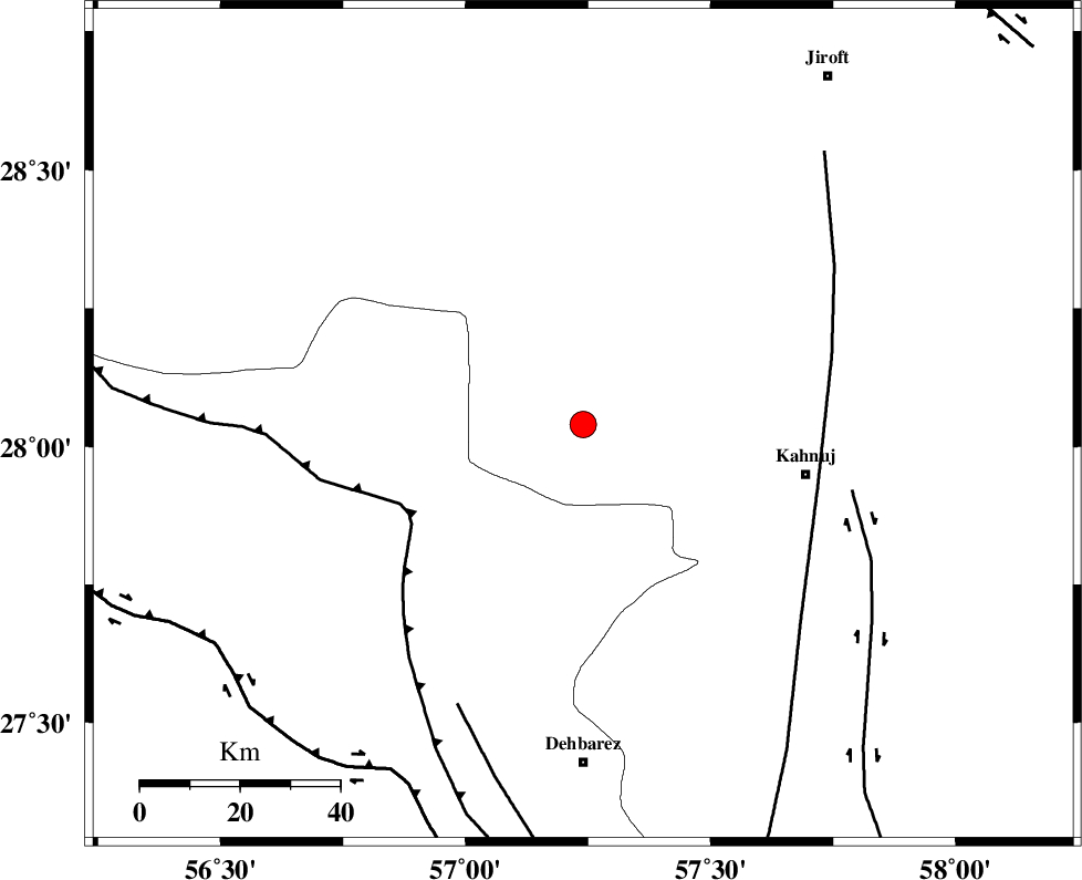
| Location | Lat:28.04 Lon: 57.24 |
| Region | Kerman Province, 46 km West of Kahnuj |
Nearest Cities |
|
| 4 km of Faryab, Kerman Province | |
| 17 km West of Mehrueye-e paeen, Kerman Province | |
| 19 km South of Hurpasefid, Kerman Province | |
| 25 km North of Fariab, Hormozgan Province | |
| 34 km North of Ziaratali, Hormozgan Province | |
| Depth | 25 km |
| Agency | |
Faults within 150 km: |
|
| MAIN_ZAGROS_R_F (Length: 1106 km) , Distance to epicenter: 37 km | |
| SABZEVARAN_F (Length: 190 km) , Distance to epicenter: 45 km | |
| ZENDAN_MINAB_F_Z1 (Length: 183 km) , Distance to epicenter: 51 km | |
| Number of Phases | 4 |
| RMS | 0 |
| Number of Stations | 4 |
| Error in Latitude | >4.7 km |
| Error in Longitude | 2.7 km |
| Error in Depth | 7.7 km |
Download waveform in seisan format
to download seisan software Click here
to access information about IIEES stations Click here
Amplitude | ||||||||
| UID | Agency | Station | Component | Amplitude | Period | Arrival Time | Proccessing Time | Signal Clip |
| 79342 | IIEES | BNDS | N | 666.8 | 0.37 | 2011-06-15 04:40:30 | 2011-06-15 04:50:00 | n |
| 79343 | IIEES | KRBR | N | 275 | 0.36 | 2011-06-15 04:40:54 | 2011-06-15 04:50:00 | n |
| 79344 | IIEES | KRBR | E | 280.5 | 0.5 | 2011-06-15 04:40:59 | 2011-06-15 04:50:00 | n |
Phase | ||||||||||||
| Agency | Station | Component | Phase Type | Phase Quality | First Motion | Observed Arrival Time | Time Residual | Loc. Flag | Input Weight | Distance | Azimuth | |
| IIEES | BNDS | Z | Pg | E | 2011-06-15 04:40:07 | 0 | y | 127 | 236 | |||
| IIEES | KRBR | Z | Pn | E | 2011-06-15 04:40:21 | 0 | y | 221 | 348 | |||
| IIEES | ZHSF | Z | Pn | E | 2011-06-15 04:40:41 | 0 | y | 387 | 62 | |||
| IIEES | GHIR | Z | Pn | E | 2011-06-15 04:40:45 | 0 | y | 418 | 275 | |||