
Magnitude |
:2.8 |
| Date & Time (UTC) | 2011-03-07 06:02:03.9 |
| Date & Time (Local) | 1389/12/16 09:32:03.9 |
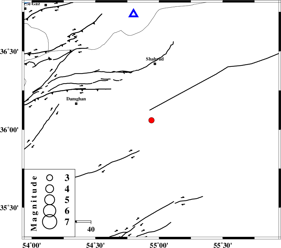
| Location | Lat:36.06 Lon: 54.94 |
| Region | Semnan Province, 40 km South of Shahrud |
Nearest Cities |
|
| 33 km South of Ruyan, Semnan Province | |
| 39 km South East of Mehmandust, Semnan Province | |
| 40 km South of Shahrud, Semnan Province | |
| 47 km South of Bastam, Semnan Province | |
| 53 km South East of Majen, Semnan Province | |
| Depth | 31 km |
| Agency | |
Faults within 150 km: |
|
| MEYAMEY_F (Length: 141 km) , Distance to epicenter: 7 km | |
| DAMGHAN_F (Length: 95 km) , Distance to epicenter: 29 km | |
| ATARI_F (Length: 185 km) , Distance to epicenter: 35 km | |
| Number of Phases | 5 |
| RMS | 0 |
| Number of Stations | 5 |
| Error in Latitude | >2.8 km |
| Error in Longitude | 3.3 km |
| Error in Depth | 6.5 km |
Download waveform in seisan format
to download seisan software Click here
to access information about IIEES stations Click here
Amplitude | ||||||||
| UID | Agency | Station | Component | Amplitude | Period | Arrival Time | Proccessing Time | Signal Clip |
| 78259 | IIEES | MRVT | N | 82 | 0.18 | 2011-03-07 06:03:07 | 2011-03-07 06:15:00 | n |
| 78260 | IIEES | NASN | E | 16.5 | 0.35 | 2011-03-07 06:04:13 | 2011-03-07 06:15:00 | n |
Phase | ||||||||||||
| Agency | Station | Component | Phase Type | Phase Quality | First Motion | Observed Arrival Time | Time Residual | Loc. Flag | Input Weight | Distance | Azimuth | |
| IIEES | SHRO | Z | Pg | E | 2011-03-07 06:02:20 | 0 | y | 96.5 | 93 | |||
| IIEES | MRVT | Z | Pg | E | 2011-03-07 06:02:36 | 0 | y | 205 | 30 | |||
| IIEES | DAMV | Z | Pn | E | 2011-03-07 06:02:44 | 0 | y | 273 | 261 | |||
| IIEES | TABS | Z | Pn | E | 2011-03-07 06:02:51 | 0 | y | 333 | 143 | |||
| IIEES | NASN | Z | Pn | E | 2011-03-07 06:03:01 | -0.1 | y | 412 | 209 | |||