
Magnitude |
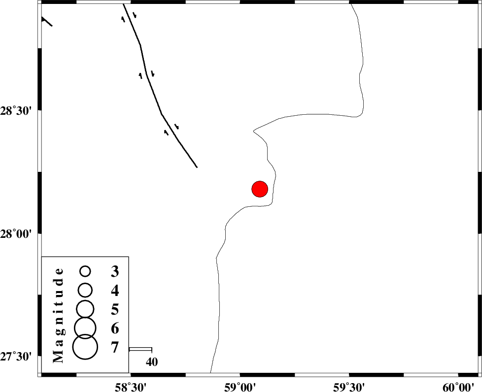
:4.6 |
| Date & Time (UTC) | 2011-01-27 15:01:43.8 |
| Date & Time (Local) | 1389/11/7 18:31:43.8 |
| Location | Lat:28.18 Lon: 59.09 |
| Region | Kerman Province, 139 km North-East of Kahnuj |
Nearest Cities |
|
| 58 km South of Hoseynabad, Kerman Province | |
| 59 km North East of Borj-e abbasabad, Kerman Province | |
| 63 km South East of Mohammadabad-e gonbaki, Kerman Province | |
| 79 km South East of Void, Kerman Province | |
| 87 km North West of Kalemursi, Sistan va Baloochestan Province | |
| Depth | 15 km |
| Agency | |
Faults within 150 km: |
|
| BAM_F (Length: 118 km) , Distance to epicenter: 30 km | |
| KANURAK_F (Length: 135 km) , Distance to epicenter: 100 km | |
| DAMAN_F (Length: 167 km) , Distance to epicenter: 112 km | |
| Number of Phases | 6 |
| RMS | 0.4 |
| Number of Stations | 7 |
| Error in Latitude | >6.2 km |
| Error in Longitude | 4.5 km |
| Error in Depth | 0 km |
Download waveform in seisan format
to download seisan software Click here
to access information about IIEES stations Click here
Amplitude | ||||||||
| UID | Agency | Station | Component | Amplitude | Period | Arrival Time | Proccessing Time | Signal Clip |
| 77441 | IIEES | BNDS | E | 2473.4 | 0.48 | 2011-01-27 15:03:14 | 2011-01-27 03:15:00 | n |
| 77442 | IIEES | BNDS | N | 2313.3 | 0.56 | 2011-01-27 15:03:16 | 2011-01-27 03:15:00 | n |
| 77443 | IIEES | KRBR | N | 2672.2 | 0.56 | 2011-01-27 15:03:12 | 2011-01-27 03:15:00 | n |
| 77444 | IIEES | KRBR | E | 2475.9 | 0.76 | 2011-01-27 15:03:15 | 2011-01-27 03:15:00 | n |
| 77445 | IIEES | TABS | E | 232.7 | 0.72 | 2011-01-27 15:04:52 | 2011-01-27 03:15:00 | n |
Phase | ||||||||||||
| Agency | Station | Component | Phase Type | Phase Quality | First Motion | Observed Arrival Time | Time Residual | Loc. Flag | Input Weight | Distance | Azimuth | |
| IIEES | ZHSF | Z | Pn | E | 2011-01-27 15:02:20 | 0.5 | y | 229 | 45 | |||
| IIEES | BNDS | Z | Pn | E | 2011-01-27 15:02:29 | 0.5 | y | 300 | 254 | |||
| IIEES | KRBR | Z | Pn | E | 2011-01-27 15:02:28 | -0.4 | y | 303 | 312 | |||
| IIEES | CHBR | Z | Pn | E | 2011-01-27 15:02:30 | -0.4 | y | 317 | 154 | |||
| IIEES | GHIR | Z | Pn | E | 2011-01-27 15:03:05 | 0 | y | 599 | 273 | |||
| IIEES | SHRT | Z | Pn | E | 2011-01-27 15:03:07 | -0.6 | y | 617 | 10 | |||