
Magnitude |
:4.2 |
| Date & Time (UTC) | 2011-01-27 09:05:21.3 |
| Date & Time (Local) | 1389/11/7 12:35:21.3 |
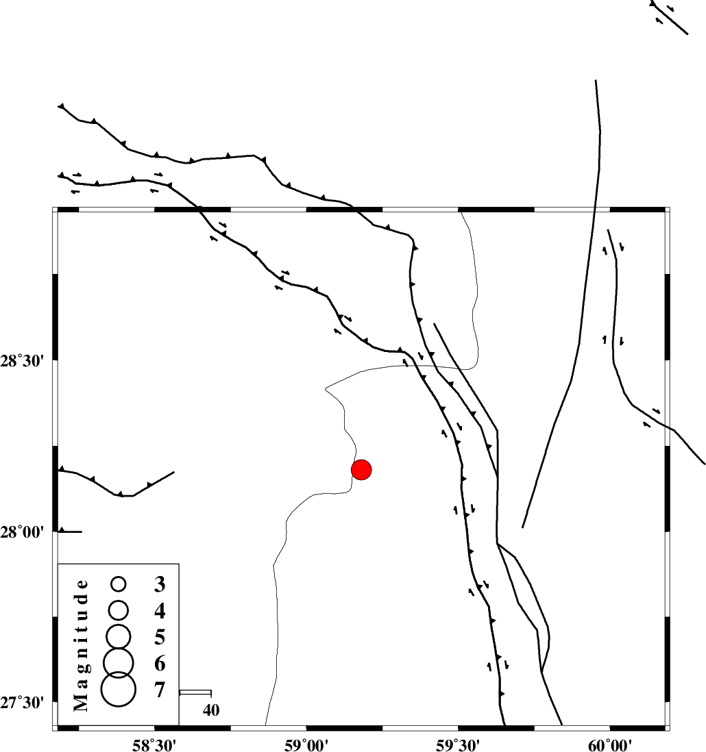
| Location | Lat:28.18 Lon: 59.18 |
| Region | Sistan va Baloochestan Province, 148 km North-East of Kahnuj |
Nearest Cities |
|
| 59 km South East of Hoseynabad, Kerman Province | |
| 67 km South East of Mohammadabad-e gonbaki, Kerman Province | |
| 67 km North East of Borj-e abbasabad, Kerman Province | |
| 82 km South East of Void, Kerman Province | |
| 84 km North West of Kalemursi, Sistan va Baloochestan Province | |
| Depth | 15 km |
| Agency | |
Faults within 150 km: |
|
| BAM_F (Length: 118 km) , Distance to epicenter: 38 km | |
| KANURAK_F (Length: 135 km) , Distance to epicenter: 96 km | |
| DAMAN_F (Length: 167 km) , Distance to epicenter: 104 km | |
| Number of Phases | 5 |
| RMS | 0.6 |
| Number of Stations | 5 |
| Error in Latitude | >16 km |
| Error in Longitude | 4.5 km |
| Error in Depth | 0 km |
Download waveform in seisan format
to download seisan software Click here
to access information about IIEES stations Click here
Amplitude | ||||||||
| UID | Agency | Station | Component | Amplitude | Period | Arrival Time | Proccessing Time | Signal Clip |
| 77381 | IIEES | BNDS | N | 1145.9 | 0.44 | 2011-01-27 09:06:48 | 2011-01-27 09:20:00 | n |
| 77382 | IIEES | KRBR | N | 850.4 | 0.32 | 2011-01-27 09:06:47 | 2011-01-27 09:20:00 | n |
| 77383 | IIEES | BNDS | E | 870.3 | 0.58 | 2011-01-27 09:06:54 | 2011-01-27 09:20:00 | n |
Phase | ||||||||||||
| Agency | Station | Component | Phase Type | Phase Quality | First Motion | Observed Arrival Time | Time Residual | Loc. Flag | Input Weight | Distance | Azimuth | |
| IIEES | ZHSF | Z | Pn | E | 2011-01-27 09:05:56 | 0.4 | y | 222 | 44 | |||
| IIEES | BNDS | Z | Pn | E | 2011-01-27 09:06:07 | -0.2 | y | 309 | 254 | |||
| IIEES | KRBR | Z | Pn | E | 2011-01-27 09:06:08 | 0.5 | y | 309 | 311 | |||
| IIEES | GHIR | Z | Pn | E | 2011-01-27 09:06:44 | 0.1 | y | 608 | 273 | |||
| IIEES | SHRT | Z | Pn | E | 2011-01-27 09:06:44 | -1.2 | y | 615 | 10 | |||