
Magnitude |
:2.6 |
| Date & Time (UTC) | 2011-01-08 11:48:34.6 |
| Date & Time (Local) | 1389/10/18 15:18:34.6 |
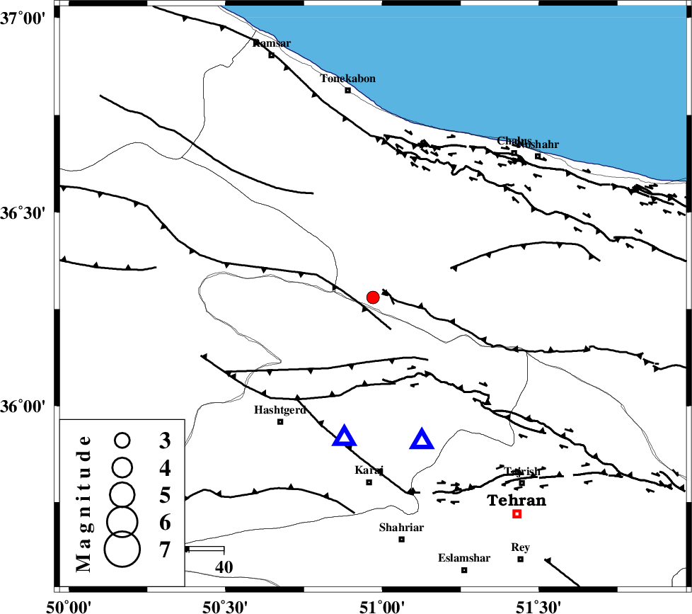
| Location | Lat:36.28 Lon: 50.97 |
| Region | Mazandaran Province, 54 km North of Karaj |
Nearest Cities |
|
| 21 km North East of Shahrak, Tehran Province | |
| 29 km North East of Taleqan, Tehran Province | |
| 30 km South West of Tavir, Mazandaran Province | |
| 32 km South West of Marzanabad, Mazandaran Province | |
| 33 km North West of Pol-e zanguleh, Mazandaran Province | |
| Depth | 15 km |
| Agency | |
Faults within 150 km: |
|
| KANDOVAN_F (Length: 90 km) , Distance to epicenter: 3 km | |
| ALAMUTRUD_F (Length: 140 km) , Distance to epicenter: 4 km | |
| TALEGHAN_F (Length: 71 km) , Distance to epicenter: 19 km | |
| Number of Phases | 3 |
| RMS | 0 |
| Number of Stations | 3 |
| Error in Latitude | >4.7 km |
| Error in Longitude | 6 km |
| Error in Depth | 0 km |
Download waveform in seisan format
to download seisan software Click here
to access information about IIEES stations Click here
Amplitude | ||||||||
| UID | Agency | Station | Component | Amplitude | Period | Arrival Time | Proccessing Time | Signal Clip |
| 77014 | IIEES | THKV | E | 684.8 | 0.28 | 2011-01-08 11:48:54 | 2011-01-08 06:12:00 | n |
| 77015 | IIEES | THKV | N | 857 | 0.74 | 2011-01-08 11:48:54 | 2011-01-08 06:12:00 | n |
| 77016 | IIEES | ZNJK | E | 26 | 1.01 | 2011-01-08 11:49:40 | 2011-01-08 06:12:00 | n |
Phase | ||||||||||||
| Agency | Station | Component | Phase Type | Phase Quality | First Motion | Observed Arrival Time | Time Residual | Loc. Flag | Input Weight | Distance | Azimuth | |
| IIEES | THKV | Z | Pg | E | 2011-01-08 11:48:42 | 0 | y | 41.6 | 191 | |||
| IIEES | CHTH | Z | Pg | E | 2011-01-08 11:48:42 | 0 | y | 44.1 | 161 | |||
| IIEES | ZNJK | Z | Pg | E | 2011-01-08 11:49:09 | 0 | y | 209 | 283 | |||