
Magnitude |
:3.5 |
| Date & Time (UTC) | 2010-11-29 03:00:27.7 |
| Date & Time (Local) | 1389/9/8 06:30:27.7 |
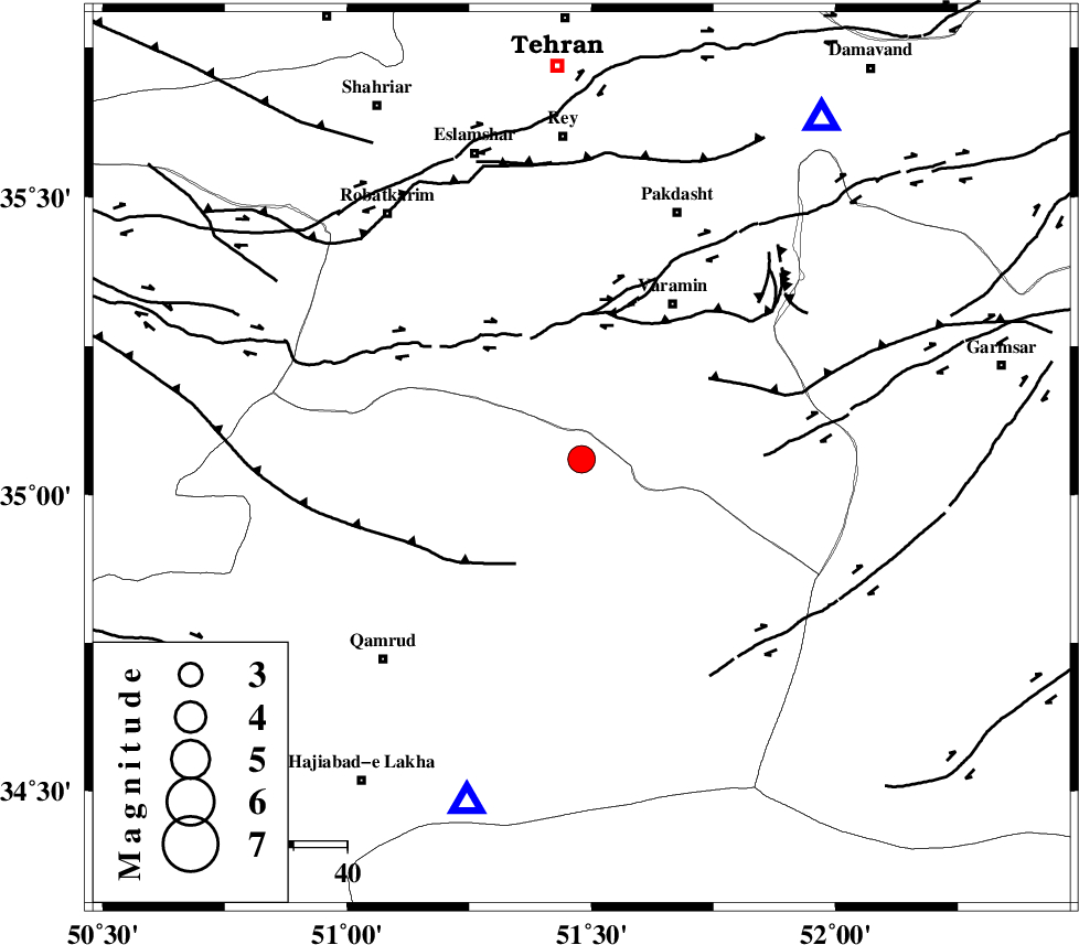
| Location | Lat:35.06 Lon: 51.48 |
| Region | Qom Province, 34 km South-West of Varamin |
Nearest Cities |
|
| 25 km South West of Ab barik, Tehran Province | |
| 31 km South of Bagh-e khavas, Tehran Province | |
| 34 km South West of Varamin, Tehran Province | |
| 36 km South West of Pishva, Tehran Province | |
| 40 km South West of Khalilabad, Tehran Province | |
| Depth | 17 km |
| Agency | |
Faults within 150 km: |
|
| SIAHKUH_F (Length: 154 km) , Distance to epicenter: 3 km | |
| PISHAV_F (Length: 34 km) , Distance to epicenter: 35 km | |
| GARMSAR_F (Length: 77 km) , Distance to epicenter: 38 km | |
| Number of Phases | 8 |
| RMS | 0.1 |
| Number of Stations | 6 |
| Error in Latitude | >1.1 km |
| Error in Longitude | 1.4 km |
| Error in Depth | 2.7 km |
Download waveform in seisan format
to download seisan software Click here
to access information about IIEES stations Click here
Amplitude | ||||||||
| UID | Agency | Station | Component | Amplitude | Period | Arrival Time | Proccessing Time | Signal Clip |
| 74770 | IIEES | GHVR | N | 1793.8 | 0.2 | 2010-11-29 03:00:49 | 2010-11-29 03:34:00 | n |
| 74771 | IIEES | GHVR | E | 4200.2 | 0.32 | 2010-11-29 03:00:49 | 2010-11-29 03:34:00 | n |
| 74772 | IIEES | DAMV | N | 3800 | 0.2 | 2010-11-29 03:00:51 | 2010-11-29 03:34:00 | n |
| 74773 | IIEES | DAMV | E | 3915.5 | 0.16 | 2010-11-29 03:00:51 | 2010-11-29 03:34:00 | n |
| 74774 | IIEES | ASAO | N | 321.8 | 0.28 | 2010-11-29 03:01:10 | 2010-11-29 03:34:00 | n |
| 74775 | IIEES | ASAO | E | 386.9 | 0.24 | 2010-11-29 03:01:12 | 2010-11-29 03:34:00 | n |
Phase | ||||||||||||
| Agency | Station | Component | Phase Type | Phase Quality | First Motion | Observed Arrival Time | Time Residual | Loc. Flag | Input Weight | Distance | Azimuth | |
| IIEES | GHVR | Z | Pg | E | 2010-11-29 03:00:39 | 0 | y | 67.7 | 198 | |||
| IIEES | DAMV | Z | Pg | E | 2010-11-29 03:00:41 | -0.1 | y | 77.6 | 35 | |||
| IIEES | DAMV | N | Sg | E | 2010-11-29 03:00:51 | 0 | y | 77.6 | 35 | |||
| IIEES | CHTH | Z | Pg | E | 2010-11-29 03:00:44 | 0.1 | y | 99.2 | 341 | |||
| IIEES | ASAO | Z | P | E | 2010-11-29 03:00:51 | 0 | y | 144 | 247 | |||
| IIEES | ASAO | E | Sg | E | 2010-11-29 03:01:09 | 0 | y | 144 | 247 | |||
| IIEES | NASN | Z | Pn | E | 2010-11-29 03:01:10 | 0 | y | 279 | 153 | |||
| IIEES | SNGE | Z | Pn | E | 2010-11-29 03:01:22 | -0.1 | y | 377 | 272 | |||