
Magnitude |
:3.1 |
| Date & Time (UTC) | 2010-11-04 21:23:13.3 |
| Date & Time (Local) | 1389/8/14 00:53:13.3 |
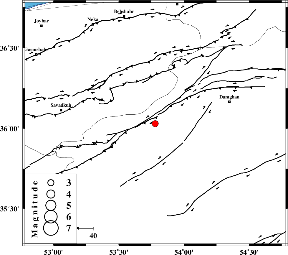
| Location | Lat:36.03 Lon: 53.78 |
| Region | Semnan Province, 53 km South-West of Damghan |
Nearest Cities |
|
| 12 km North West of Darvar, Semnan Province | |
| 21 km South of Talma darreh, Mazandaran Province | |
| 31 km South East of Kiasar, Mazandaran Province | |
| 33 km North West of Amirabad, Semnan Province | |
| 33 km West of Seydabad, Semnan Province | |
| Depth | 16 km |
| Agency | |
Faults within 150 km: |
|
| DAMGHAN_F (Length: 95 km) , Distance to epicenter: 14 km | |
| ATARI_F (Length: 185 km) , Distance to epicenter: 16 km | |
| ASTANEH_F (Length: 72 km) , Distance to epicenter: 30 km | |
| Number of Phases | 5 |
| RMS | 0.3 |
| Number of Stations | 5 |
| Error in Latitude | >7.7 km |
| Error in Longitude | 3.6 km |
| Error in Depth | 0 km |
Download waveform in seisan format
to download seisan software Click here
to access information about IIEES stations Click here
Amplitude | ||||||||
| UID | Agency | Station | Component | Amplitude | Period | Arrival Time | Proccessing Time | Signal Clip |
| 72887 | IIEES | GHVR | E | 123 | 0.32 | 2010-11-04 21:24:42 | 2010-11-05 06:20:00 | n |
| 72888 | IIEES | GHVR | N | 147.2 | 0.4 | 2010-11-04 21:24:42 | 2010-11-05 06:20:00 | n |
| 72889 | IIEES | ASAO | E | 21.6 | 0.6 | 2010-11-04 21:25:16 | 2010-11-05 06:20:00 | n |
| 72890 | IIEES | ASAO | N | 24 | 0.6 | 2010-11-04 21:25:17 | 2010-11-05 06:20:00 | n |
Phase | ||||||||||||
| Agency | Station | Component | Phase Type | Phase Quality | First Motion | Observed Arrival Time | Time Residual | Loc. Flag | Input Weight | Distance | Azimuth | |
| IIEES | CHTH | Z | Pn | E | 2010-11-04 21:23:51 | 0.2 | y | 240 | 268 | |||
| IIEES | MRVT | Z | Pn | E | 2010-11-04 21:23:54 | 0 | y | 274 | 48 | |||
| IIEES | GHVR | N | Pn | E | 2010-11-04 21:23:56 | 0.4 | y | 288 | 234 | |||
| IIEES | NASN | Z | Pn | E | 2010-11-04 21:24:07 | 0 | y | 369 | 194 | |||
| IIEES | ASAO | Z | Pn | E | 2010-11-04 21:24:07 | -0.7 | y | 379 | 245 | |||