
Magnitude |
:3.8 |
| Date & Time (UTC) | 2010-11-02 17:41:50.5 |
| Date & Time (Local) | 1389/8/11 21:11:50.5 |
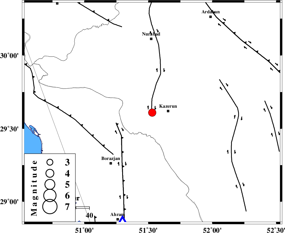
| Location | Lat:29.61 Lon: 51.53 |
| Region | Fars Province, 12 km West of Kazerun |
Nearest Cities |
|
| 6 km of Kamaraj, Fars Province | |
| 9 km of Deris, Fars Province | |
| 12 km West of Kazerun, Fars Province | |
| 14 km North West of Mehranjan, Fars Province | |
| 19 km North East of Khesht, Fars Province | |
| Depth | 14 km |
| Agency | |
Faults within 150 km: |
|
| KAZERUN_F (Length: 96 km) , Distance to epicenter: 3 km | |
| BORAZJAN_F (Length: 168 km) , Distance to epicenter: 28 km | |
| ZFF3 (Length: 125 km) , Distance to epicenter: 43 km | |
| Number of Phases | 10 |
| RMS | 0.1 |
| Number of Stations | 8 |
| Error in Latitude | >2.9 km |
| Error in Longitude | 1.4 km |
| Error in Depth | 9.1 km |
Download waveform in seisan format
to download seisan software Click here
to access information about IIEES stations Click here
Amplitude | ||||||||
| UID | Agency | Station | Component | Amplitude | Period | Arrival Time | Proccessing Time | Signal Clip |
| 72730 | IIEES | GHIR | N | 786.7 | 0.4 | 2010-11-02 17:43:07 | 2010-11-02 05:56:00 | n |
| 72731 | IIEES | GHIR | E | 983.7 | 0.68 | 2010-11-02 17:43:09 | 2010-11-02 05:56:00 | n |
| 72732 | IIEES | SHGR | E | 426.5 | 0.56 | 2010-11-02 17:43:46 | 2010-11-02 05:56:00 | n |
| 72733 | IIEES | KRBR | N | 62 | 0.68 | 2010-11-02 17:44:31 | 2010-11-02 05:56:00 | n |
| 72734 | IIEES | KRBR | E | 67 | 0.72 | 2010-11-02 17:44:44 | 2010-11-02 05:56:00 | n |
Phase | ||||||||||||
| Agency | Station | Component | Phase Type | Phase Quality | First Motion | Observed Arrival Time | Time Residual | Loc. Flag | Input Weight | Distance | Azimuth | |
| IIEES | AHRM | Z | Pg | E | 2010-11-02 17:42:05 | 0 | y | 85.4 | 195 | |||
| IIEES | AHRM | E | Sg | E | 2010-11-02 17:42:15 | 0 | y | 85.4 | 195 | |||
| IIEES | GHIR | Z | P | E | 2010-11-02 17:42:23 | 0.1 | y | 204 | 135 | |||
| IIEES | GHIR | N | Sg | E | 2010-11-02 17:42:48 | -0.1 | y | 204 | 135 | |||
| IIEES | NASN | Z | P | E | 2010-11-02 17:42:44 | 0 | y | 374 | 19 | |||
| IIEES | SHGR | Z | P | E | 2010-11-02 17:42:45 | 0 | y | 380 | 317 | |||
| IIEES | KHMZ | Z | P | E | 2010-11-02 17:42:58 | 0 | y | 481 | 342 | |||
| IIEES | KRBR | Z | Pn | E | 2010-11-02 17:43:01 | 0.1 | y | 508 | 84 | |||
| IIEES | ASAO | Z | P | E | 2010-11-02 17:43:08 | 0 | y | 566 | 346 | |||
| IIEES | DAMV | Z | Pn | E | 2010-11-02 17:43:21 | -0.2 | y | 669 | 3 | |||