
Magnitude |
:4.6 |
| Date & Time (UTC) | 2010-10-22 08:00:37.6 |
| Date & Time (Local) | 1389/7/30 11:30:37.6 |
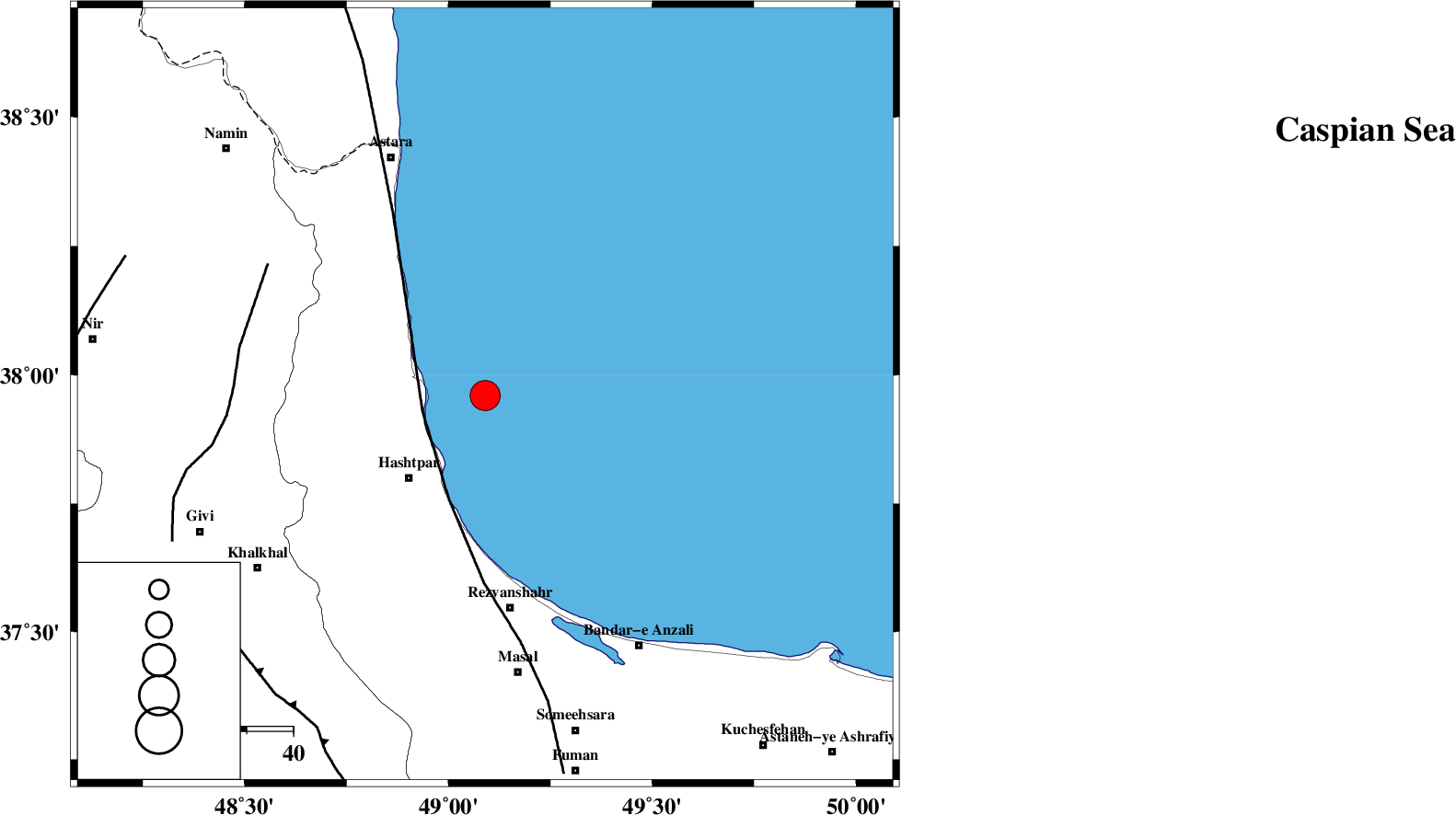
| Location | Lat:37.96 Lon: 49.09 |
| Region | Caspian Sea, 24 km North-East of Hashtpar |
Nearest Cities |
|
| 14 km East of Lisar, Gilan Province | |
| 19 km North East of Chelonasr, Gilan Province | |
| 24 km North East of Hashtpar, Gilan Province | |
| 24 km North East of Hashtpar, Gilan Province | |
| 27 km North East of Tularud, Gilan Province | |
| Depth | 15 km |
| Agency | |
Faults within 150 km: |
|
| TALESH_F (Length: 258 km) , Distance to epicenter: 14 km | |
| SANGAVAR_F (Length: 61 km) , Distance to epicenter: 53 km | |
| MASULEL_F (Length: 90 km) , Distance to epicenter: 72 km | |
| Number of Phases | 6 |
| RMS | 0.2 |
| Number of Stations | 7 |
| Error in Latitude | >7.1 km |
| Error in Longitude | 7.8 km |
| Error in Depth | 8.4 km |
Download waveform in seisan format
to download seisan software Click here
to access information about IIEES stations Click here
Amplitude | ||||||||
| UID | Agency | Station | Component | Amplitude | Period | Arrival Time | Proccessing Time | Signal Clip |
| 72210 | IIEES | ZNJK | E | 8047.3 | 0.72 | 2010-10-22 08:01:21 | 2010-10-22 08:45:00 | n |
| 72211 | IIEES | MAKU | N | 734.3 | 0.69 | 2010-10-22 08:02:35 | 2010-10-22 08:45:00 | n |
| 72212 | IIEES | BJRD | N | 179.6 | 1.67 | 2010-10-22 08:03:30 | 2010-10-22 08:45:00 | n |
| 72213 | IIEES | BJRD | E | 141.6 | 0.61 | 2010-10-22 08:03:30 | 2010-10-22 08:45:00 | n |
Phase | ||||||||||||
| Agency | Station | Component | Phase Type | Phase Quality | First Motion | Observed Arrival Time | Time Residual | Loc. Flag | Input Weight | Distance | Azimuth | |
| IIEES | ZNJK | Z | Pg | E | 2010-10-22 08:01:02 | -0.2 | y | 147 | 194 | |||
| IIEES | CHTH | Z | Pn | E | 2010-10-22 08:01:21 | 0.1 | y | 291 | 141 | |||
| IIEES | SNGE | Z | Pn | E | 2010-10-22 08:01:29 | 0.3 | y | 354 | 207 | |||
| IIEES | MAKU | Z | Pn | E | 2010-10-22 08:01:36 | -0.1 | y | 413 | 293 | |||
| IIEES | KHMZ | Z | Pn | E | 2010-10-22 08:01:44 | 0.2 | y | 475 | 170 | |||
| IIEES | NASN | Z | Pn | E | 2010-10-22 08:02:07 | -0.3 | y | 665 | 148 | |||