
Magnitude |
:3.4 |
| Date & Time (UTC) | 2010-10-13 13:27:56.9 |
| Date & Time (Local) | 1389/7/21 16:57:56.9 |
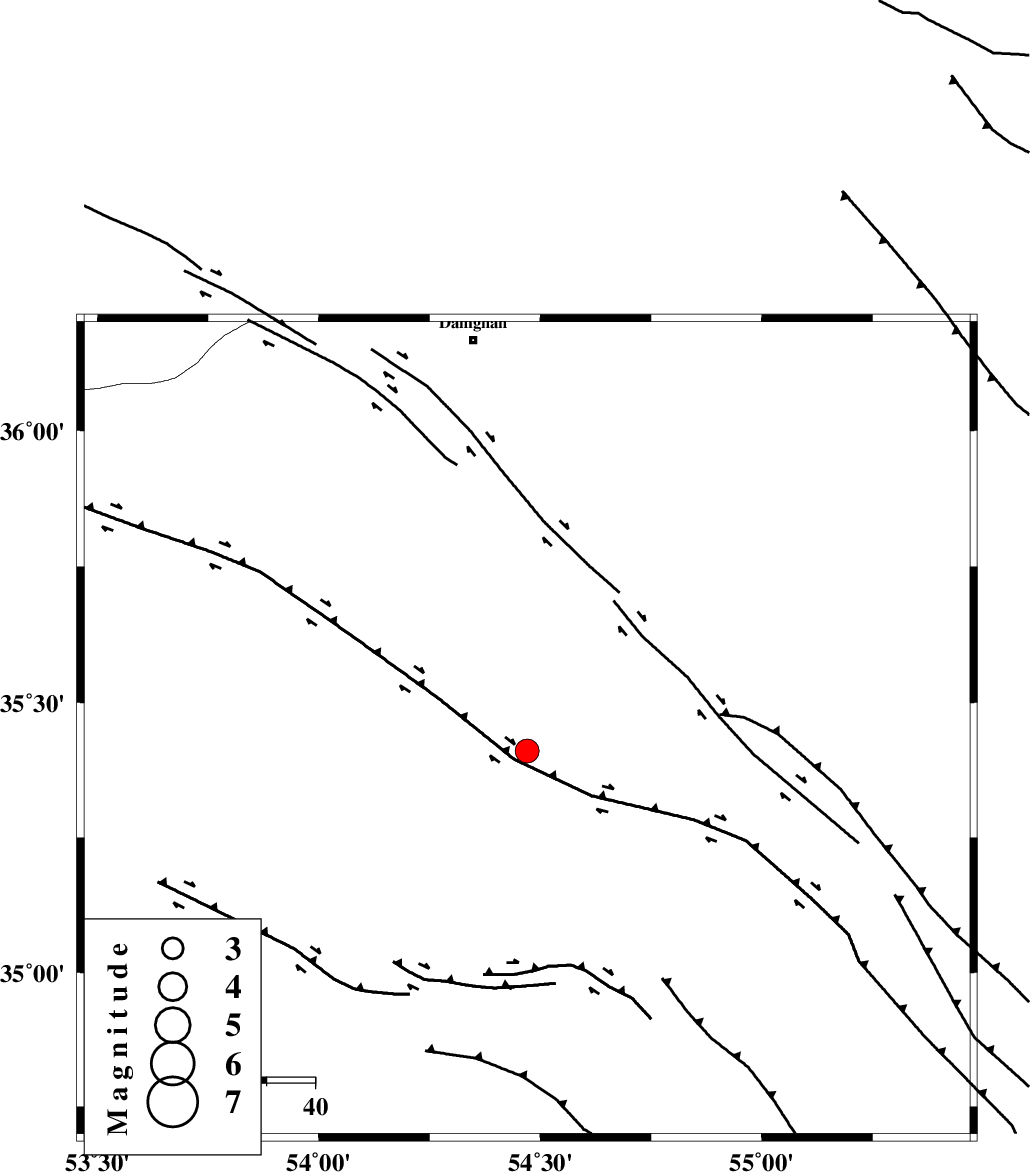
| Location | Lat:35.45 Lon: 54.47 |
| Region | Semnan Province, 81 km South-East of Damghan |
Nearest Cities |
|
| 71 km South East of Amirabad, Semnan Province | |
| 73 km South East of Seydabad, Semnan Province | |
| 79 km South East of Darvar, Semnan Province | |
| 80 km South East of Damghan, Semnan Province | |
| 86 km South of Mehmandust, Semnan Province | |
| Depth | 14 km |
| Agency | |
Faults within 150 km: |
|
| TORUD_F (Length: 136 km) , Distance to epicenter: 19 km | |
| ATARI_F (Length: 185 km) , Distance to epicenter: 75 km | |
| MEYAMEY_F (Length: 141 km) , Distance to epicenter: 85 km | |
| Number of Phases | 9 |
| RMS | 0.1 |
| Number of Stations | 7 |
| Error in Latitude | >2.3 km |
| Error in Longitude | 1.2 km |
| Error in Depth | 3.6 km |
Download waveform in seisan format
to download seisan software Click here
to access information about IIEES stations Click here
Amplitude | ||||||||
| UID | Agency | Station | Component | Amplitude | Period | Arrival Time | Proccessing Time | Signal Clip |
| 71810 | IIEES | DAMV | E | 378.7 | 0.48 | 2010-10-13 13:29:02 | 2010-10-13 01:46:00 | n |
| 71811 | IIEES | DAMV | N | 365.7 | 0.48 | 2010-10-13 13:29:07 | 2010-10-13 01:46:00 | n |
| 71812 | IIEES | MRVT | E | 99.1 | 0.44 | 2010-10-13 13:29:17 | 2010-10-13 01:46:00 | n |
| 71813 | IIEES | GHVR | N | 97.8 | 0.36 | 2010-10-13 13:29:36 | 2010-10-13 01:46:00 | n |
| 71814 | IIEES | GHVR | E | 104.1 | 0.4 | 2010-10-13 13:29:36 | 2010-10-13 01:46:00 | n |
Phase | ||||||||||||
| Agency | Station | Component | Phase Type | Phase Quality | First Motion | Observed Arrival Time | Time Residual | Loc. Flag | Input Weight | Distance | Azimuth | |
| IIEES | SHRO | Z | P | E | 2010-10-13 13:28:21 | -0.1 | y | 153 | 66 | |||
| IIEES | SHRO | E | Sg | E | 2010-10-13 13:28:40 | 0 | y | 153 | 66 | |||
| IIEES | DAMV | Z | P | E | 2010-10-13 13:28:33 | 0.2 | y | 228 | 276 | |||
| IIEES | DAMV | N | Sg | E | 2010-10-13 13:29:01 | -0.1 | y | 228 | 276 | |||
| IIEES | MRVT | Z | P | E | 2010-10-13 13:28:40 | 0.1 | y | 285 | 30 | |||
| IIEES | GHVR | Z | P | E | 2010-10-13 13:28:43 | 0.1 | y | 313 | 251 | |||
| IIEES | TABS | Z | P | E | 2010-10-13 13:28:43 | 0.1 | y | 315 | 129 | |||
| IIEES | NASN | Z | P | E | 2010-10-13 13:28:45 | -0.2 | y | 331 | 208 | |||
| IIEES | BJRD | Z | P | E | 2010-10-13 13:28:49 | -0.1 | y | 363 | 46 | |||