
Magnitude |
:3.3 |
| Date & Time (UTC) | 2010-09-25 14:57:42.1 |
| Date & Time (Local) | 1389/7/3 18:27:42.1 |
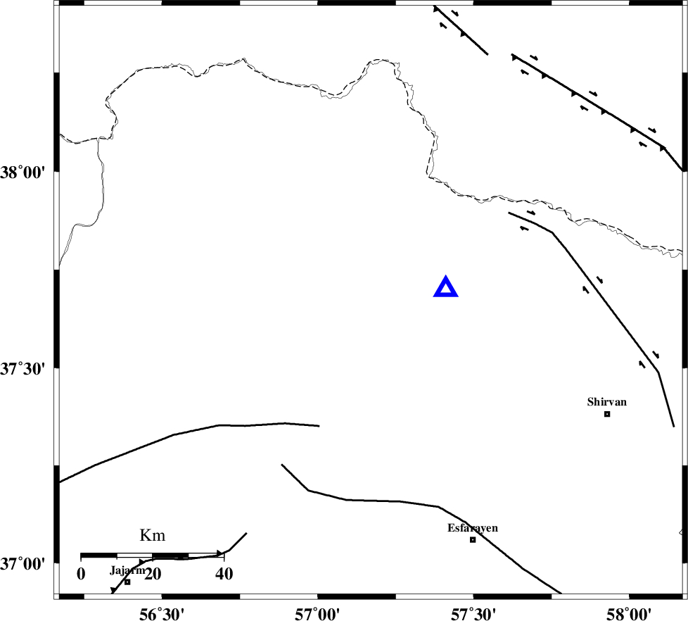
| Location | Lat:37.67 Lon: 57.17 |
| Region | Khorasan(north) Province, 24 km North-East of Ashkhaneh |
Nearest Cities |
|
| 15 km North East of Pish qaleh, Khorasan(north) Province | |
| 24 km North East of Ashkhaneh, Khorasan(north) Province | |
| 26 km North West of Bojnurd, Khorasan(north) Province | |
| 26 km North West of Void, Khorasan(north) Province | |
| 30 km South of Raz, Khorasan(north) Province | |
| Depth | 17 km |
| Agency | |
Faults within 150 km: |
|
| ROBATE_QARABIL_F (Length: 168 km) , Distance to epicenter: 38 km | |
| BAGHAN_GERMAB_F (Length: 79 km) , Distance to epicenter: 46 km | |
| ESFARAYEN_F (Length: 111 km) , Distance to epicenter: 53 km | |
| Number of Phases | 5 |
| RMS | 0.2 |
| Number of Stations | 4 |
| Error in Latitude | >6.7 km |
| Error in Longitude | 4 km |
| Error in Depth | 7.5 km |
Download waveform in seisan format
to download seisan software Click here
to access information about IIEES stations Click here
Amplitude | ||||||||
| UID | Agency | Station | Component | Amplitude | Period | Arrival Time | Proccessing Time | Signal Clip |
| 70910 | IIEES | BJRD | N | 9513.3 | 0.31 | 2010-09-25 14:57:50 | 2010-09-25 03:24:00 | n |
| 70911 | IIEES | BJRD | E | 3673.6 | 0.39 | 2010-09-25 14:57:50 | 2010-09-25 03:24:00 | n |
Phase | ||||||||||||
| Agency | Station | Component | Phase Type | Phase Quality | First Motion | Observed Arrival Time | Time Residual | Loc. Flag | Input Weight | Distance | Azimuth | |
| IIEES | BJRD | Z | Pg | E | 2010-09-25 14:57:47 | 0.3 | y | 21 | 80 | |||
| IIEES | BJRD | E | Sg | E | 2010-09-25 14:57:50 | -0.2 | y | 21 | 80 | |||
| IIEES | MRVT | Z | Pg | E | 2010-09-25 14:57:58 | -0.1 | y | 95.6 | 270 | |||
| IIEES | SHRO | N | Pg | E | 2010-09-25 14:58:16 | 0.1 | y | 211 | 210 | |||
| IIEES | TABS | Z | Pn | E | 2010-09-25 14:58:44 | -0.1 | y | 446 | 181 | |||