
Magnitude |
:2.7 |
| Date & Time (UTC) | 2010-09-19 03:11:40.3 |
| Date & Time (Local) | 1389/6/28 07:41:40.3 |
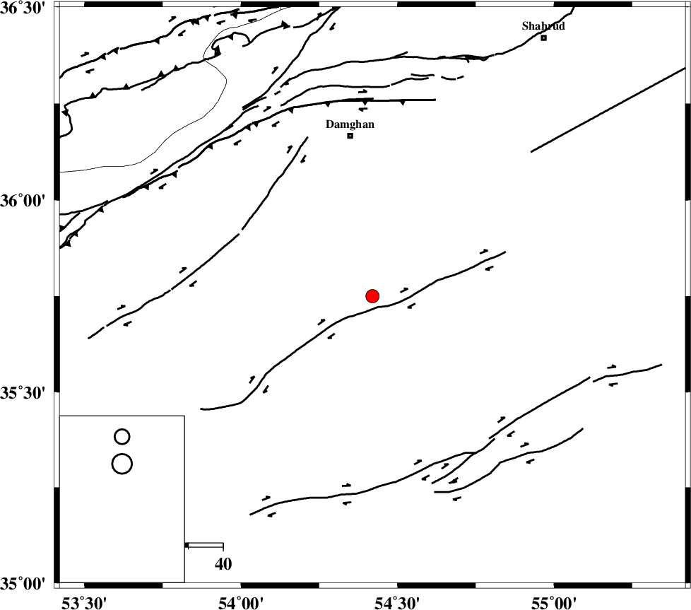
| Location | Lat:35.75 Lon: 54.42 |
| Region | Semnan Province, 47 km South of Damghan |
Nearest Cities |
|
| 39 km South East of Amirabad, Semnan Province | |
| 42 km South East of Seydabad, Semnan Province | |
| 47 km South of Damghan, Semnan Province | |
| 53 km South West of Mehmandust, Semnan Province | |
| 54 km South East of Darvar, Semnan Province | |
| Depth | 14 km |
| Agency | |
Faults within 150 km: |
|
| ATARI_F (Length: 185 km) , Distance to epicenter: 47 km | |
| TORUD_F (Length: 136 km) , Distance to epicenter: 51 km | |
| DAMGHAN_F (Length: 95 km) , Distance to epicenter: 56 km | |
| Number of Phases | 7 |
| RMS | 0.2 |
| Number of Stations | 5 |
| Error in Latitude | >5.6 km |
| Error in Longitude | 2.5 km |
| Error in Depth | 5.5 km |
Download waveform in seisan format
to download seisan software Click here
to access information about IIEES stations Click here
Amplitude | ||||||||
| UID | Agency | Station | Component | Amplitude | Period | Arrival Time | Proccessing Time | Signal Clip |
| 70670 | IIEES | DAMV | E | 65.9 | 0.14 | 2010-09-19 03:12:53 | 2010-09-19 03:27:00 | n |
| 70671 | IIEES | TABS | N | 19.7 | 0.37 | 2010-09-19 03:13:28 | 2010-09-19 03:27:00 | n |
| 70672 | IIEES | NASN | N | 15.5 | 0.47 | 2010-09-19 03:13:16 | 2010-09-19 03:27:00 | n |
Phase | ||||||||||||
| Agency | Station | Component | Phase Type | Phase Quality | First Motion | Observed Arrival Time | Time Residual | Loc. Flag | Input Weight | Distance | Azimuth | |
| IIEES | SHRO | Z | Pg | E | 2010-09-19 03:12:04 | -0.3 | y | 147 | 78 | |||
| IIEES | SHRO | N | Sg | E | 2010-09-19 03:12:22 | 0.2 | y | 147 | 78 | |||
| IIEES | DAMV | Z | Pn | E | 2010-09-19 03:12:15 | 0 | y | 222 | 267 | |||
| IIEES | GHVR | Z | Pn | E | 2010-09-19 03:12:28 | 0.2 | y | 322 | 245 | |||
| IIEES | GHVR | E | Sg | E | 2010-09-19 03:13:10 | 0.1 | y | 322 | 245 | |||
| IIEES | TABS | Z | Pn | E | 2010-09-19 03:12:30 | 0.1 | y | 340 | 132 | |||
| IIEES | NASN | Z | Pn | E | 2010-09-19 03:12:32 | -0.3 | y | 359 | 205 | |||