
Magnitude |
:3 |
| Date & Time (UTC) | 2010-09-11 23:24:57.5 |
| Date & Time (Local) | 1389/6/21 03:54:57.5 |
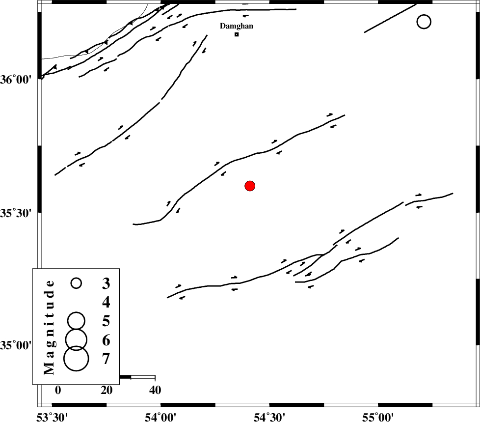
| Location | Lat:35.53 Lon: 54.45 |
| Region | Semnan Province, 72 km South-East of Damghan |
Nearest Cities |
|
| 62 km South East of Amirabad, Semnan Province | |
| 64 km South East of Seydabad, Semnan Province | |
| 71 km South East of Damghan, Semnan Province | |
| 71 km South East of Darvar, Semnan Province | |
| 77 km South West of Mehmandust, Semnan Province | |
| Depth | 14 km |
| Agency | |
Faults within 150 km: |
|
| TORUD_F (Length: 136 km) , Distance to epicenter: 28 km | |
| ATARI_F (Length: 185 km) , Distance to epicenter: 68 km | |
| MEYAMEY_F (Length: 141 km) , Distance to epicenter: 79 km | |
| Number of Phases | 4 |
| RMS | 0.2 |
| Number of Stations | 4 |
| Error in Latitude | >5.5 km |
| Error in Longitude | 4.1 km |
| Error in Depth | 8 km |
Download waveform in seisan format
to download seisan software Click here
to access information about IIEES stations Click here
Amplitude | ||||||||
| UID | Agency | Station | Component | Amplitude | Period | Arrival Time | Proccessing Time | Signal Clip |
| 70290 | IIEES | DAMV | E | 139.8 | 0.59 | 2010-09-11 23:26:03 | 2010-09-12 02:39:00 | n |
| 70291 | IIEES | DAMV | N | 108.8 | 0.74 | 2010-09-11 23:26:08 | 2010-09-12 02:39:00 | n |
| 70292 | IIEES | MRVT | E | 51.9 | 0.35 | 2010-09-11 23:26:18 | 2010-09-12 02:39:00 | n |
| 70293 | IIEES | TABS | N | 42.9 | 0.47 | 2010-09-11 23:26:40 | 2010-09-12 02:39:00 | n |
Phase | ||||||||||||
| Agency | Station | Component | Phase Type | Phase Quality | First Motion | Observed Arrival Time | Time Residual | Loc. Flag | Input Weight | Distance | Azimuth | |
| IIEES | SHRO | Z | Pg | E | 2010-09-11 23:25:22 | -0.3 | y | 151 | 69 | |||
| IIEES | DAMV | Z | Pg | E | 2010-09-11 23:25:34 | -0.1 | y | 225 | 274 | |||
| IIEES | MRVT | Z | Pn | E | 2010-09-11 23:25:40 | 0.2 | y | 278 | 31 | |||
| IIEES | TABS | Z | P | E | 2010-09-11 23:25:45 | 0.1 | y | 321 | 130 | |||