
Magnitude |
:3.2 |
| Date & Time (UTC) | 2010-09-10 10:28:37.8 |
| Date & Time (Local) | 1389/6/19 14:58:37.8 |
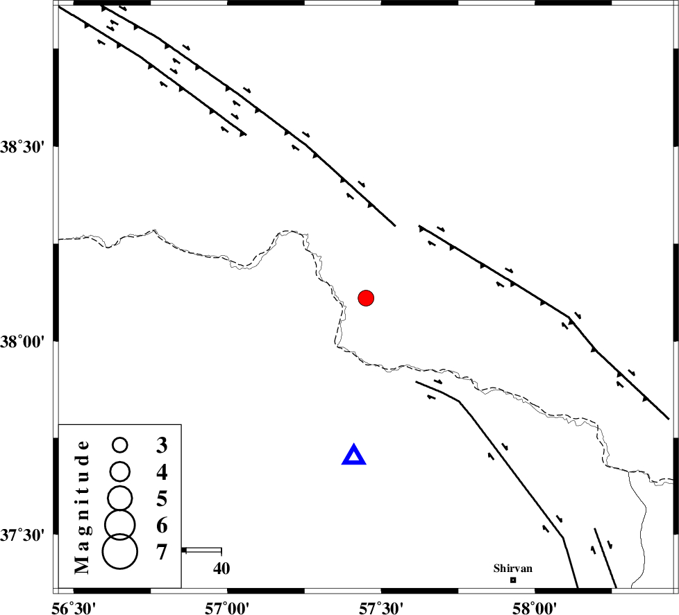
| Location | Lat:38.11 Lon: 57.45 |
| Region | 72 km North-East of Bojnurd |
Nearest Cities |
|
| 24 km North of Gifan olia, Khorasan(north) Province | |
| 35 km North East of Raz, Khorasan(north) Province | |
| 48 km North East of Tangehzar, Khorasan(north) Province | |
| 48 km North West of Yangi ghale-ye bala, Khorasan(north) Province | |
| 61 km North West of Tukur, Khorasan(north) Province | |
| Depth | 14 km |
| Agency | |
Faults within 150 km: |
|
| MAIN_KOPEHDAGH_F2 (Length: 131 km) , Distance to epicenter: 22 km | |
| MAIN_KOPEHDAGH_F3 (Length: 96 km) , Distance to epicenter: 26 km | |
| BAGHAN_GERMAB_F (Length: 79 km) , Distance to epicenter: 28 km | |
| Number of Phases | 5 |
| RMS | 0.2 |
| Number of Stations | 3 |
| Error in Latitude | >3.9 km |
| Error in Longitude | 6.6 km |
| Error in Depth | 7.4 km |
Download waveform in seisan format
to download seisan software Click here
to access information about IIEES stations Click here
Amplitude | ||||||||
| UID | Agency | Station | Component | Amplitude | Period | Arrival Time | Proccessing Time | Signal Clip |
| 70192 | IIEES | BJRD | E | 2469.2 | 0.23 | 2010-09-10 10:28:53 | 2010-09-10 10:40:00 | n |
| 70193 | IIEES | MRVT | E | 457.1 | 1.17 | 2010-09-10 10:29:22 | 2010-09-10 10:40:00 | n |
| 70194 | IIEES | MRVT | N | 532.8 | 1.05 | 2010-09-10 10:29:23 | 2010-09-10 10:40:00 | n |
Phase | ||||||||||||
| Agency | Station | Component | Phase Type | Phase Quality | First Motion | Observed Arrival Time | Time Residual | Loc. Flag | Input Weight | Distance | Azimuth | |
| IIEES | BJRD | Z | Pg | E | 2010-09-10 10:28:46 | 0.1 | y | 45.8 | 184 | |||
| IIEES | BJRD | N | Sg | E | 2010-09-10 10:28:52 | -0.2 | y | 45.8 | 184 | |||
| IIEES | MRVT | Z | Pg | E | 2010-09-10 10:28:59 | -0.2 | y | 130 | 248 | |||
| IIEES | SHRO | Z | Pn | E | 2010-09-10 10:29:18 | 0.1 | y | 266 | 209 | |||
| IIEES | SHRO | E | Sg | E | 2010-09-10 10:29:53 | 0.2 | y | 266 | 209 | |||