
Magnitude |
:2.9 |
| Date & Time (UTC) | 2010-09-09 19:21:18.5 |
| Date & Time (Local) | 1389/6/18 23:51:18.5 |
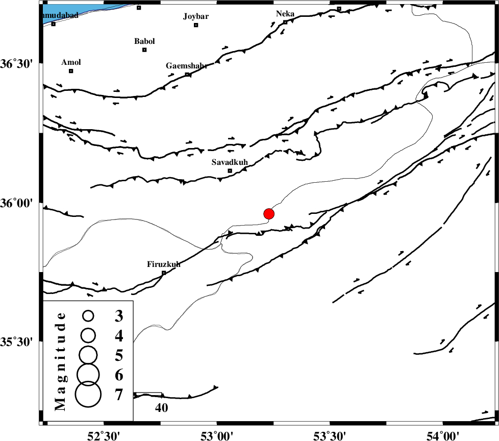
| Location | Lat:35.96 Lon: 53.23 |
| Region | Semnan Province, 23 km South-East of Pol-E-Sefid |
Nearest Cities |
|
| 8 km North of Chashem, Semnan Province | |
| 12 km South of Sangdeh, Mazandaran Province | |
| 22 km South East of Shurmast-e peyrudbar, Mazandaran Province | |
| 23 km South East of Pol-E-Sefid, Mazandaran Province | |
| 23 km North of Shahmirzad, Semnan Province | |
| Depth | 15 km |
| Agency | |
Faults within 150 km: |
|
| N_ALBORZ_F (Length: 360 km) , Distance to epicenter: 28 km | |
| ATARI_F (Length: 185 km) , Distance to epicenter: 31 km | |
| DAMGHAN_F (Length: 95 km) , Distance to epicenter: 58 km | |
| Number of Phases | 6 |
| RMS | 0.2 |
| Number of Stations | 7 |
| Error in Latitude | >5.9 km |
| Error in Longitude | 1.5 km |
| Error in Depth | 0 km |
Download waveform in seisan format
to download seisan software Click here
to access information about IIEES stations Click here
Amplitude | ||||||||
| UID | Agency | Station | Component | Amplitude | Period | Arrival Time | Proccessing Time | Signal Clip |
| 70150 | IIEES | DAMV | N | 187.8 | 0.48 | 2010-09-09 19:21:56 | 2010-09-09 07:33:00 | n |
| 70151 | IIEES | DAMV | E | 196.8 | 0.31 | 2010-09-09 19:21:59 | 2010-09-09 07:33:00 | n |
| 70152 | IIEES | THKV | E | 117 | 0.44 | 2010-09-09 19:22:29 | 2010-09-09 07:33:00 | n |
| 70153 | IIEES | THKV | N | 62.1 | 0.4 | 2010-09-09 19:22:31 | 2010-09-09 07:33:00 | n |
| 70154 | IIEES | GHVR | N | 147.9 | 0.4 | 2010-09-09 19:22:34 | 2010-09-09 07:33:00 | n |
| 70155 | IIEES | GHVR | E | 152.3 | 0.44 | 2010-09-09 19:22:35 | 2010-09-09 07:33:00 | n |
Phase | ||||||||||||
| Agency | Station | Component | Phase Type | Phase Quality | First Motion | Observed Arrival Time | Time Residual | Loc. Flag | Input Weight | Distance | Azimuth | |
| IIEES | CHTH | Z | Pn | E | 2010-09-09 19:21:49 | -0.2 | y | 190 | 269 | |||
| IIEES | THKV | E | Pn | E | 2010-09-09 19:21:52 | 0.2 | y | 212 | 269 | |||
| IIEES | GHVR | Z | Pn | E | 2010-09-09 19:21:56 | 0.2 | y | 244 | 228 | |||
| IIEES | SHRO | E | Pn | E | 2010-09-09 19:21:57 | -0.1 | y | 251 | 88 | |||
| IIEES | MRVT | N | Pn | E | 2010-09-09 19:22:05 | 0.1 | y | 317 | 53 | |||
| IIEES | ASAO | Z | Pn | E | 2010-09-09 19:22:07 | -0.2 | y | 331 | 243 | |||