
Magnitude |
:2.7 |
| Date & Time (UTC) | 2010-09-08 05:35:18.4 |
| Date & Time (Local) | 1389/6/17 10:05:18.4 |
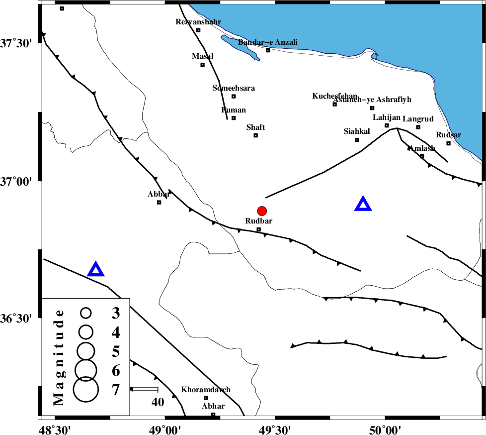
| Location | Lat:36.89 Lon: 49.44 |
| Region | Gilan Province, 7 km Rudbar |
Nearest Cities |
|
| 5 km North of Rostamabad, Gilan Province | |
| 8 km North of Rudbar, Gilan Province | |
| 11 km of Nasir mahalleh, Gilan Province | |
| 17 km North of Manjil, Gilan Province | |
| 21 km North West of Dashtvil, Gilan Province | |
| Depth | 23 km |
| Agency | |
Faults within 150 km: |
|
| LAHIJAN_F (Length: 92 km) , Distance to epicenter: 6 km | |
| RUDBAR_F (Length: 93 km) , Distance to epicenter: 9 km | |
| MASULEL_F (Length: 90 km) , Distance to epicenter: 39 km | |
| Number of Phases | 7 |
| RMS | 0.2 |
| Number of Stations | 6 |
| Error in Latitude | >3.9 km |
| Error in Longitude | 2.6 km |
| Error in Depth | 4.8 km |
Download waveform in seisan format
to download seisan software Click here
to access information about IIEES stations Click here
Amplitude | ||||||||
| UID | Agency | Station | Component | Amplitude | Period | Arrival Time | Proccessing Time | Signal Clip |
| 70070 | IIEES | THKV | E | 78.2 | 0.2 | 2010-09-08 05:36:07 | 2010-09-08 06:26:00 | n |
| 70071 | IIEES | DAMV | E | 46.9 | 0.42 | 2010-09-08 05:36:34 | 2010-09-08 06:26:00 | n |
Phase | ||||||||||||
| Agency | Station | Component | Phase Type | Phase Quality | First Motion | Observed Arrival Time | Time Residual | Loc. Flag | Input Weight | Distance | Azimuth | |
| IIEES | ZNJK | Z | Pg | E | 2010-09-08 05:35:31 | 0.1 | y | 71.5 | 251 | |||
| IIEES | THKV | Z | Pg | E | 2010-09-08 05:35:46 | 0.2 | y | 168 | 129 | |||
| IIEES | CHTH | Z | Pg | E | 2010-09-08 05:35:48 | -0.3 | y | 186 | 125 | |||
| IIEES | CHTH | N | Sg | E | 2010-09-08 05:36:10 | 0 | y | 186 | 125 | |||
| IIEES | GRMI | Z | Pn | E | 2010-09-08 05:35:56 | 0 | y | 253 | 328 | |||
| IIEES | DAMV | Z | Pn | E | 2010-09-08 05:35:58 | 0.1 | y | 267 | 121 | |||
| IIEES | SNGE | Z | Pn | E | 2010-09-08 05:35:59 | -0.1 | y | 274 | 224 | |||