
Magnitude |
:3.8 |
| Date & Time (UTC) | 2010-09-04 21:15:13.9 |
| Date & Time (Local) | 1389/6/14 01:45:13.9 |
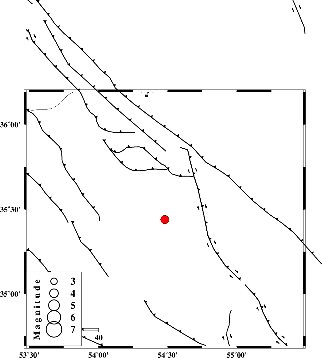
| Location | Lat:35.44 Lon: 54.48 |
| Region | Semnan Province, 82 km South-East of Damghan |
Nearest Cities |
|
| 72 km South East of Amirabad, Semnan Province | |
| 75 km South East of Seydabad, Semnan Province | |
| 81 km South East of Darvar, Semnan Province | |
| 82 km South East of Damghan, Semnan Province | |
| 87 km South of Mehmandust, Semnan Province | |
| Depth | 14 km |
| Agency | |
Faults within 150 km: |
|
| TORUD_F (Length: 136 km) , Distance to epicenter: 18 km | |
| ATARI_F (Length: 185 km) , Distance to epicenter: 76 km | |
| MEYAMEY_F (Length: 141 km) , Distance to epicenter: 86 km | |
| Number of Phases | 8 |
| RMS | 0.4 |
| Number of Stations | 7 |
| Error in Latitude | >8 km |
| Error in Longitude | 3.9 km |
| Error in Depth | 11.3 km |
Download waveform in seisan format
to download seisan software Click here
to access information about IIEES stations Click here
Amplitude | ||||||||
| UID | Agency | Station | Component | Amplitude | Period | Arrival Time | Proccessing Time | Signal Clip |
| 69910 | IIEES | DAMV | N | 613.9 | 1.02 | 2010-09-04 21:16:22 | 2010-09-04 09:35:00 | n |
| 69911 | IIEES | DAMV | E | 727 | 0.74 | 2010-09-04 21:16:27 | 2010-09-04 09:35:00 | n |
| 69912 | IIEES | MRVT | E | 397.2 | 0.12 | 2010-09-04 21:16:38 | 2010-09-04 09:35:00 | n |
| 69913 | IIEES | TABS | N | 574 | 0.37 | 2010-09-04 21:16:57 | 2010-09-04 09:35:00 | n |
| 69914 | IIEES | GHVR | N | 386.4 | 0.35 | 2010-09-04 21:16:52 | 2010-09-04 09:35:00 | n |
Phase | ||||||||||||
| Agency | Station | Component | Phase Type | Phase Quality | First Motion | Observed Arrival Time | Time Residual | Loc. Flag | Input Weight | Distance | Azimuth | |
| IIEES | SHRO | Z | Pg | E | 2010-09-04 21:15:39 | -0.3 | y | 152 | 65 | |||
| IIEES | SHRO | E | Sg | E | 2010-09-04 21:15:57 | -0.1 | y | 152 | 65 | |||
| IIEES | DAMV | Z | Pg | E | 2010-09-04 21:15:50 | -0.7 | y | 229 | 276 | |||
| IIEES | DAMV | N | Sg | E | 2010-09-04 21:16:19 | 0.1 | y | 229 | 276 | |||
| IIEES | MRVT | Z | Pn | E | 2010-09-04 21:15:57 | 0.3 | y | 286 | 30 | |||
| IIEES | CHTH | Z | Pn | E | 2010-09-04 21:16:00 | 0.6 | y | 308 | 281 | |||
| IIEES | TABS | Z | Pn | E | 2010-09-04 21:16:00 | 0.4 | y | 313 | 129 | |||
| IIEES | NASN | Z | Pn | E | 2010-09-04 21:16:02 | -0.2 | y | 331 | 208 | |||