
Magnitude |
:2.8 |
| Date & Time (UTC) | 2010-09-01 19:38:05.8 |
| Date & Time (Local) | 1389/6/11 00:08:05.8 |
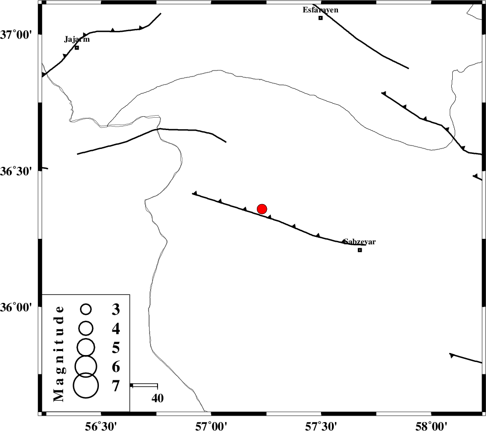
| Location | Lat:36.36 Lon: 57.23 |
| Region | Khorasan(center) Province, 43 km North-West of Sabzevar |
Nearest Cities |
|
| 15 km North East of Sadkharu, Khorasan(center) Province | |
| 17 km North West of Rivand, Khorasan(center) Province | |
| 28 km South of Abuchenari, Khorasan(center) Province | |
| 32 km North East of Davarzan, Khorasan(center) Province | |
| 34 km South East of Jogtay, Khorasan(center) Province | |
| Depth | 23 km |
| Agency | |
Faults within 150 km: |
|
| SABZEVAR_F (Length: 81 km) , Distance to epicenter: 9 km | |
| JOGHATAI_F (Length: 70 km) , Distance to epicenter: 31 km | |
| RIVAND_F (Length: 70 km) , Distance to epicenter: 68 km | |
| Number of Phases | 5 |
| RMS | 0.1 |
| Number of Stations | 4 |
| Error in Latitude | >2.1 km |
| Error in Longitude | 4 km |
| Error in Depth | 8 km |
Download waveform in seisan format
to download seisan software Click here
to access information about IIEES stations Click here
Amplitude | ||||||||
| UID | Agency | Station | Component | Amplitude | Period | Arrival Time | Proccessing Time | Signal Clip |
| 69757 | IIEES | TABS | N | 38.4 | 0.64 | 2010-09-01 19:39:40 | 2010-09-01 08:21:00 | n |
Phase | ||||||||||||
| Agency | Station | Component | Phase Type | Phase Quality | First Motion | Observed Arrival Time | Time Residual | Loc. Flag | Input Weight | Distance | Azimuth | |
| IIEES | SHRO | Z | Pg | E | 2010-09-01 19:38:25 | 0 | y | 116 | 251 | |||
| IIEES | BJRD | Z | Pg | E | 2010-09-01 19:38:30 | 0.1 | y | 150 | 6 | |||
| IIEES | MRVT | Z | Pg | E | 2010-09-01 19:38:34 | -0.2 | y | 177 | 325 | |||
| IIEES | MRVT | N | Sg | E | 2010-09-01 19:38:55 | 0.1 | y | 177 | 325 | |||
| IIEES | TABS | Z | Pn | E | 2010-09-01 19:38:50 | 0 | y | 300 | 182 | |||