
Magnitude |
:4 |
| Date & Time (UTC) | 2010-09-01 19:28:03.7 |
| Date & Time (Local) | 1389/6/10 23:58:03.7 |
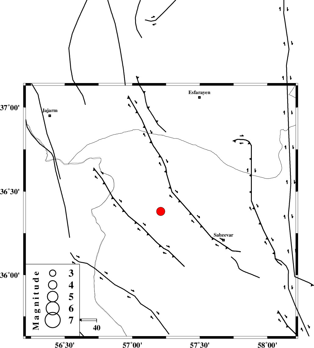
| Location | Lat:36.38 Lon: 57.21 |
| Region | Khorasan(center) Province, 46 km North-West of Sabzevar |
Nearest Cities |
|
| 15 km North East of Sadkharu, Khorasan(center) Province | |
| 20 km North West of Rivand, Khorasan(center) Province | |
| 26 km South of Abuchenari, Khorasan(center) Province | |
| 30 km North East of Davarzan, Khorasan(center) Province | |
| 31 km South East of Jogtay, Khorasan(center) Province | |
| Depth | 25 km |
| Agency | |
Faults within 150 km: |
|
| SABZEVAR_F (Length: 81 km) , Distance to epicenter: 11 km | |
| JOGHATAI_F (Length: 70 km) , Distance to epicenter: 28 km | |
| RIVAND_F (Length: 70 km) , Distance to epicenter: 68 km | |
| Number of Phases | 7 |
| RMS | 0 |
| Number of Stations | 8 |
| Error in Latitude | >1.8 km |
| Error in Longitude | 2.8 km |
| Error in Depth | 3.6 km |
Download waveform in seisan format
to download seisan software Click here
to access information about IIEES stations Click here
Amplitude | ||||||||
| UID | Agency | Station | Component | Amplitude | Period | Arrival Time | Proccessing Time | Signal Clip |
| 69750 | IIEES | TABS | E | 371.4 | 0.56 | 2010-09-01 19:29:36 | 2010-09-01 08:21:00 | n |
| 69751 | IIEES | TABS | N | 706.4 | 0.72 | 2010-09-01 19:29:38 | 2010-09-01 08:21:00 | n |
| 69752 | IIEES | SHRT | E | 219.3 | 0.8 | 2010-09-01 19:30:10 | 2010-09-01 08:21:00 | n |
| 69753 | IIEES | DAMV | E | 150 | 0.68 | 2010-09-01 19:30:39 | 2010-09-01 08:21:00 | n |
Phase | ||||||||||||
| Agency | Station | Component | Phase Type | Phase Quality | First Motion | Observed Arrival Time | Time Residual | Loc. Flag | Input Weight | Distance | Azimuth | |
| IIEES | SHRO | Z | Pg | E | 2010-09-01 19:28:22 | 0 | y | 115 | 249 | |||
| IIEES | BJRD | Z | Pg | E | 2010-09-01 19:28:27 | 0.1 | y | 148 | 7 | |||
| IIEES | MRVT | Z | Pg | E | 2010-09-01 19:28:31 | -0.1 | y | 174 | 325 | |||
| IIEES | TABS | Z | Pn | E | 2010-09-01 19:28:48 | 0 | y | 303 | 182 | |||
| IIEES | DAMV | Z | Pn | E | 2010-09-01 19:29:10 | 0 | y | 480 | 262 | |||
| IIEES | NASN | Z | Pn | E | 2010-09-01 19:29:21 | 0 | y | 566 | 227 | |||
| IIEES | GHVR | Z | P | E | 2010-09-01 19:29:22 | 0 | y | 581 | 250 | |||