
Magnitude |
:3.3 |
| Date & Time (UTC) | 2010-08-27 20:11:08.1 |
| Date & Time (Local) | 1389/6/6 00:41:08.1 |
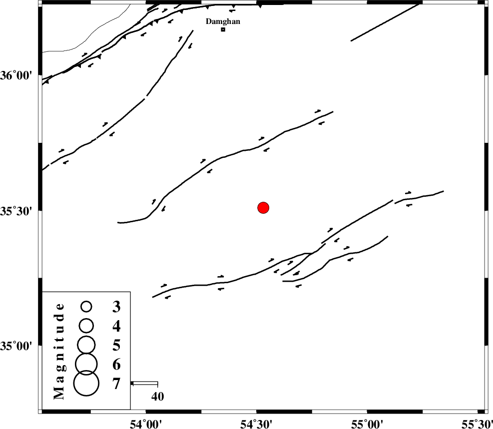
| Location | Lat:35.51 Lon: 54.53 |
| Region | Semnan Province, 75 km South-East of Damghan |
Nearest Cities |
|
| 67 km South East of Amirabad, Semnan Province | |
| 70 km South East of Seydabad, Semnan Province | |
| 75 km South East of Damghan, Semnan Province | |
| 78 km South East of Darvar, Semnan Province | |
| 79 km South of Mehmandust, Semnan Province | |
| Depth | 15 km |
| Agency | |
Faults within 150 km: |
|
| TORUD_F (Length: 136 km) , Distance to epicenter: 23 km | |
| ATARI_F (Length: 185 km) , Distance to epicenter: 75 km | |
| MEYAMEY_F (Length: 141 km) , Distance to epicenter: 77 km | |
| Number of Phases | 6 |
| RMS | 0.3 |
| Number of Stations | 6 |
| Error in Latitude | >6.4 km |
| Error in Longitude | 5.1 km |
| Error in Depth | 9.8 km |
Download waveform in seisan format
to download seisan software Click here
to access information about IIEES stations Click here
Amplitude | ||||||||
| UID | Agency | Station | Component | Amplitude | Period | Arrival Time | Proccessing Time | Signal Clip |
| 69589 | IIEES | DAMV | E | 350.2 | 0.28 | 2010-08-27 20:12:16 | 2010-08-29 12:45:00 | n |
| 69590 | IIEES | DAMV | N | 347.5 | 0.56 | 2010-08-27 20:12:17 | 2010-08-29 12:45:00 | n |
| 69591 | IIEES | MRVT | E | 98 | 0.28 | 2010-08-27 20:12:27 | 2010-08-29 12:45:00 | n |
| 69592 | IIEES | MRVT | N | 100.7 | 0.4 | 2010-08-27 20:12:28 | 2010-08-29 12:45:00 | n |
| 69593 | IIEES | GHVR | N | 105.6 | 0.52 | 2010-08-27 20:12:51 | 2010-08-29 12:45:00 | n |
Phase | ||||||||||||
| Agency | Station | Component | Phase Type | Phase Quality | First Motion | Observed Arrival Time | Time Residual | Loc. Flag | Input Weight | Distance | Azimuth | |
| IIEES | SHRO | Z | Pg | E | 2010-08-27 20:11:31 | -0.3 | y | 145 | 67 | |||
| IIEES | DAMV | Z | Pn | E | 2010-08-27 20:11:44 | -0.4 | y | 233 | 274 | |||
| IIEES | MRVT | Z | Pn | E | 2010-08-27 20:11:50 | 0.3 | y | 277 | 30 | |||
| IIEES | CHTH | Z | Pn | E | 2010-08-27 20:11:54 | 0.1 | y | 312 | 279 | |||
| IIEES | TABS | Z | Pn | E | 2010-08-27 20:11:54 | 0.1 | y | 314 | 130 | |||
| IIEES | GHVR | Z | Pn | E | 2010-08-27 20:11:55 | 0.1 | y | 321 | 250 | |||