
Magnitude |
:3 |
| Date & Time (UTC) | 2010-08-24 04:11:00.1 |
| Date & Time (Local) | 1389/6/2 08:41:00.1 |
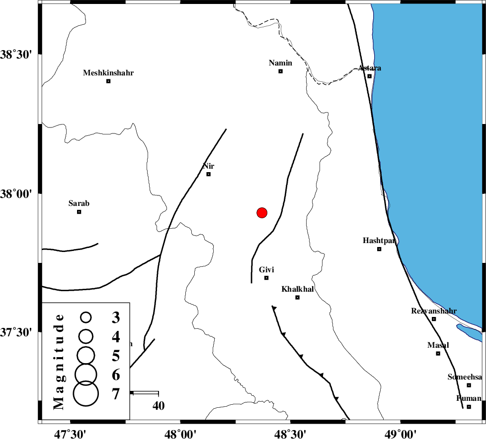
| Location | Lat:37.93 Lon: 48.37 |
| Region | Ardebil Province, 26 km North of Givi |
Nearest Cities |
|
| 10 km East of Kuraeim, Ardebil Province | |
| 15 km South of Budalalu, Ardebil Province | |
| 16 km South of Mehmandust, Ardebil Province | |
| 26 km North of Givi, Ardebil Province | |
| 26 km South East of Nir, Ardebil Province | |
| Depth | 14 km |
| Agency | |
Faults within 150 km: |
|
| SANGAVAR_F (Length: 61 km) , Distance to epicenter: 8 km | |
| BOZQUSH (Length: 70 km) , Distance to epicenter: 32 km | |
| MASULEL_F (Length: 90 km) , Distance to epicenter: 37 km | |
| Number of Phases | 9 |
| RMS | 0.2 |
| Number of Stations | 7 |
| Error in Latitude | >3.6 km |
| Error in Longitude | 7.6 km |
| Error in Depth | 5.8 km |
Download waveform in seisan format
to download seisan software Click here
to access information about IIEES stations Click here
Amplitude | ||||||||
| UID | Agency | Station | Component | Amplitude | Period | Arrival Time | Proccessing Time | Signal Clip |
| 69537 | IIEES | ZNJK | N | 242.2 | 0.34 | 2010-08-24 04:11:48 | 2010-08-29 12:45:00 | n |
| 69538 | IIEES | THKV | N | 104.6 | 0.49 | 2010-08-24 04:12:30 | 2010-08-29 12:45:00 | n |
| 69539 | IIEES | ASAO | E | 16.3 | 0.64 | 2010-08-24 04:12:58 | 2010-08-29 12:45:00 | n |
Phase | ||||||||||||
| Agency | Station | Component | Phase Type | Phase Quality | First Motion | Observed Arrival Time | Time Residual | Loc. Flag | Input Weight | Distance | Azimuth | |
| IIEES | GRMI | Z | Pg | E | 2010-08-24 04:11:18 | -0.2 | y | 107 | 337 | |||
| IIEES | GRMI | N | Sg | E | 2010-08-24 04:11:31 | 0 | y | 107 | 337 | |||
| IIEES | ZNJK | Z | Pg | E | 2010-08-24 04:11:23 | -0.2 | y | 142 | 168 | |||
| IIEES | THKV | Z | Pn | E | 2010-08-24 04:11:47 | 0.6 | y | 316 | 134 | |||
| IIEES | THKV | N | Sg | E | 2010-08-24 04:12:28 | -0.3 | y | 316 | 134 | |||
| IIEES | CHTH | Z | Pn | E | 2010-08-24 04:11:49 | 0 | y | 333 | 131 | |||
| IIEES | ASAO | Z | Pn | E | 2010-08-24 04:11:58 | 0 | y | 403 | 158 | |||
| IIEES | DAMV | Z | Pn | E | 2010-08-24 04:11:59 | 0.1 | y | 410 | 127 | |||
| IIEES | SHRO | Z | Pn | E | 2010-08-24 04:12:36 | -0.1 | y | 713 | 105 | |||