
Magnitude |
:2.9 |
| Date & Time (UTC) | 2010-08-22 10:40:47.2 |
| Date & Time (Local) | 1389/5/31 15:10:47.2 |
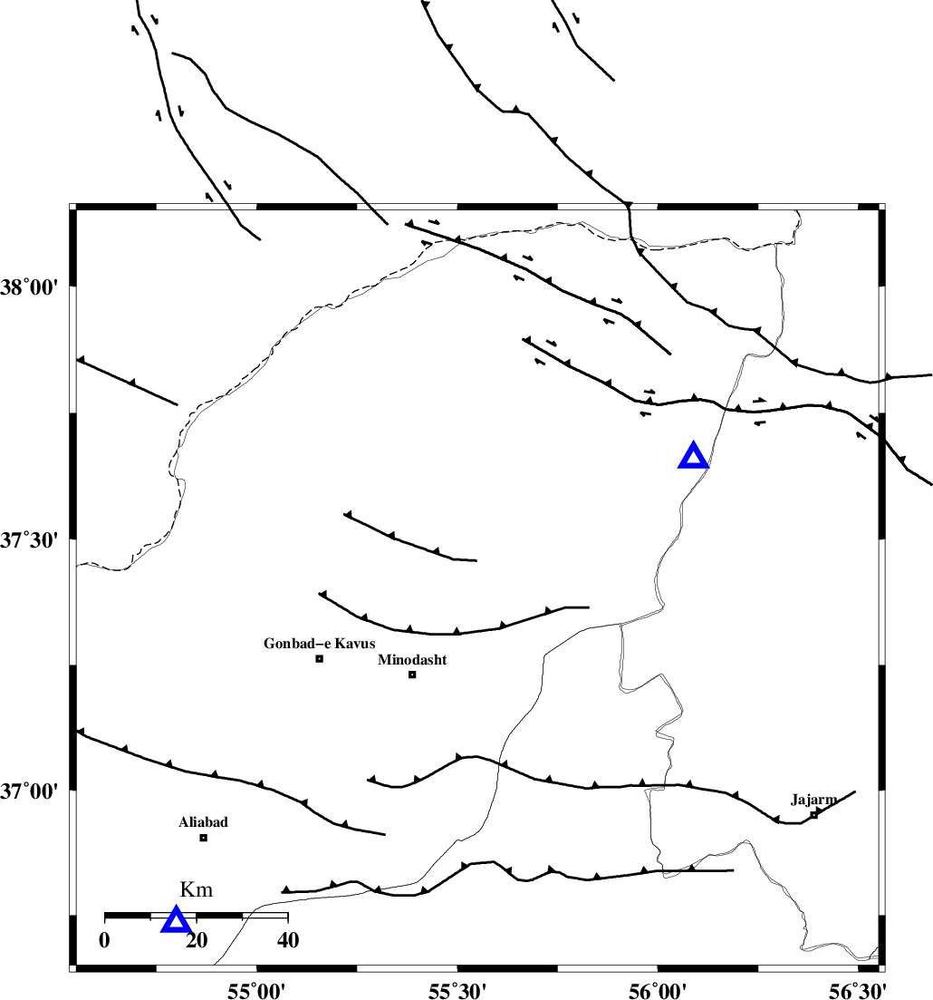
| Location | Lat:37.4 Lon: 55.55 |
| Region | Golestan Province, 6 km Kalaleh |
Nearest Cities |
|
| 2 km of Ajen sangarli, Golestan Province | |
| 6 km North of Kalaleh, Golestan Province | |
| 7 km North of Aq qamish, Golestan Province | |
| 10 km of Tamarqarquzi-e sofla, Golestan Province | |
| 14 km North East of Kangur, Golestan Province | |
| Depth | 14 km |
| Agency | |
Faults within 150 km: |
|
| ROBATE_QARABIL_F (Length: 168 km) , Distance to epicenter: 40 km | |
| KHAZAR_F (Length: 523 km) , Distance to epicenter: 68 km | |
| SHAVAR_F (Length: 87 km) , Distance to epicenter: 76 km | |
| Number of Phases | 5 |
| RMS | 0.3 |
| Number of Stations | 4 |
| Error in Latitude | >5.9 km |
| Error in Longitude | 22.5 km |
| Error in Depth | 14.8 km |
Download waveform in seisan format
to download seisan software Click here
to access information about IIEES stations Click here
Amplitude | ||||||||
| UID | Agency | Station | Component | Amplitude | Period | Arrival Time | Proccessing Time | Signal Clip |
| 69515 | IIEES | MRVT | N | 1343.4 | 0.39 | 2010-08-22 10:41:04 | 2010-08-29 12:45:00 | n |
| 69516 | IIEES | MRVT | E | 1224.7 | 0.22 | 2010-08-22 10:41:04 | 2010-08-29 12:45:00 | n |
| 69517 | IIEES | BJRD | N | 79.3 | 0.35 | 2010-08-22 10:41:36 | 2010-08-29 12:45:00 | n |
Phase | ||||||||||||
| Agency | Station | Component | Phase Type | Phase Quality | First Motion | Observed Arrival Time | Time Residual | Loc. Flag | Input Weight | Distance | Azimuth | |
| IIEES | MRVT | Z | Pg | E | 2010-08-22 10:40:56 | -0.4 | y | 55.8 | 59 | |||
| IIEES | SHRO | Z | Pg | E | 2010-08-22 10:41:13 | 0.1 | y | 160 | 165 | |||
| IIEES | SHRO | N | Sg | E | 2010-08-22 10:41:32 | -0.2 | y | 160 | 165 | |||
| IIEES | BJRD | Z | Pg | E | 2010-08-22 10:41:15 | 0.4 | y | 168 | 78 | |||
| IIEES | TABS | Z | Pn | E | 2010-08-22 10:41:49 | 0.2 | y | 440 | 161 | |||