
Magnitude |
:3.5 |
| Date & Time (UTC) | 2010-08-20 10:57:30.4 |
| Date & Time (Local) | 1389/5/29 15:27:30.4 |
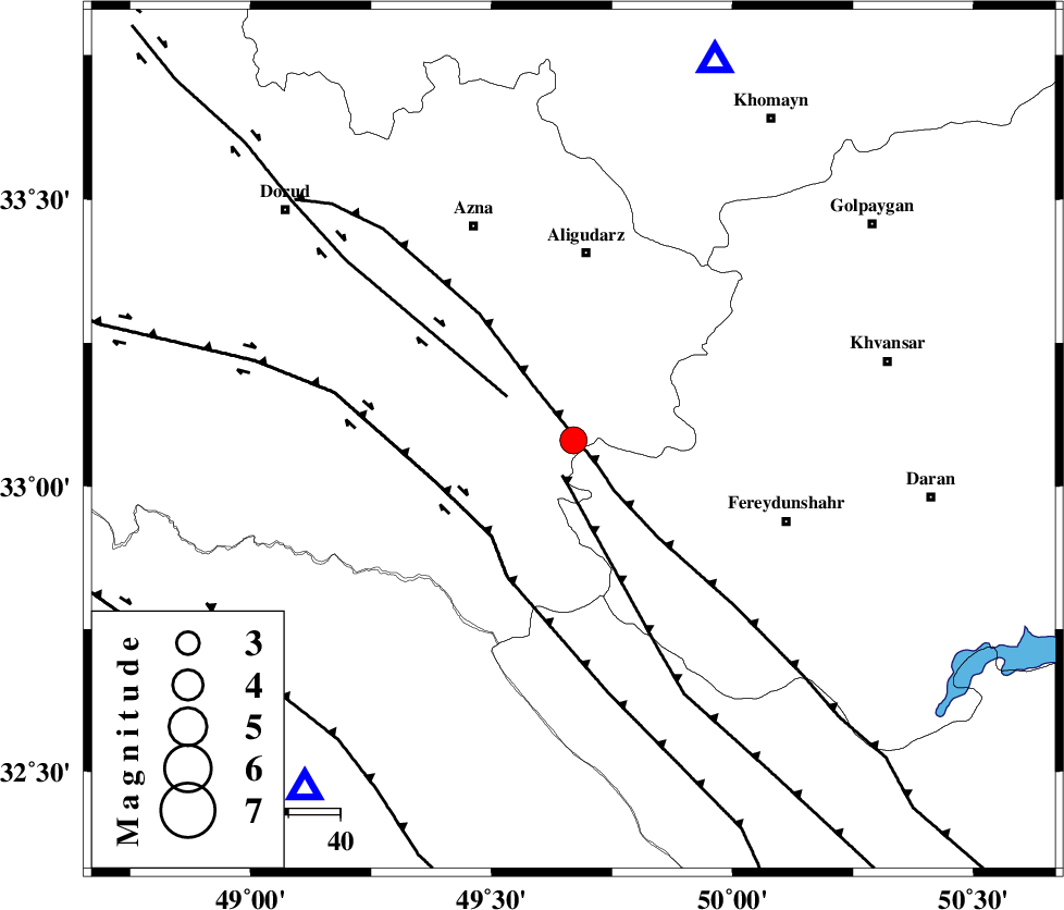
| Location | Lat:33.08 Lon: 49.67 |
| Region | Lorestan Province, 36 km South of Aligudarz |
Nearest Cities |
|
| 18 km West of Farsesh, Lorestan Province | |
| 19 km South of Shapoorabad, Lorestan Province | |
| 19 km South of Shapoorabad, Lorestan Province | |
| 26 km North East of Parchal, Lorestan Province | |
| 31 km North West of Masir, Esfahan Province | |
| Depth | 15 km |
| Agency | |
Faults within 150 km: |
|
| MAIN_ZAGROS_R_F (Length: 1106 km) , Distance to epicenter: 3 km | |
| ARDAL_F (Length: 170 km) , Distance to epicenter: 7 km | |
| DORUD (Length: 100 km) , Distance to epicenter: 15 km | |
| Number of Phases | 7 |
| RMS | 0.4 |
| Number of Stations | 7 |
| Error in Latitude | >6 km |
| Error in Longitude | 8.1 km |
| Error in Depth | 9.5 km |
Download waveform in seisan format
to download seisan software Click here
to access information about IIEES stations Click here
Amplitude | ||||||||
| UID | Agency | Station | Component | Amplitude | Period | Arrival Time | Proccessing Time | Signal Clip |
| 69487 | IIEES | SHGR | E | 912.9 | 0.4 | 2010-08-20 10:58:15 | 2010-08-29 12:45:00 | n |
| 69488 | IIEES | SHGR | N | 984.7 | 0.56 | 2010-08-20 10:58:15 | 2010-08-29 12:45:00 | n |
| 69489 | IIEES | ASAO | N | 597.8 | 0.64 | 2010-08-20 10:58:23 | 2010-08-29 12:45:00 | n |
| 69490 | IIEES | GHVR | E | 282.9 | 0.76 | 2010-08-20 10:58:39 | 2010-08-29 12:45:00 | n |
Phase | ||||||||||||
| Agency | Station | Component | Phase Type | Phase Quality | First Motion | Observed Arrival Time | Time Residual | Loc. Flag | Input Weight | Distance | Azimuth | |
| IIEES | SHGR | Z | Pg | E | 2010-08-20 10:57:52 | -0.3 | y | 135 | 217 | |||
| IIEES | ASAO | Z | Pg | E | 2010-08-20 10:57:57 | -0.7 | y | 166 | 11 | |||
| IIEES | GHVR | Z | Pg | E | 2010-08-20 10:58:05 | -0.3 | y | 213 | 43 | |||
| IIEES | NASN | Z | Pn | E | 2010-08-20 10:58:15 | 0.3 | y | 295 | 95 | |||
| IIEES | SNGE | Z | Pn | E | 2010-08-20 10:58:17 | 0.4 | y | 309 | 317 | |||
| IIEES | DAMV | Z | Pn | E | 2010-08-20 10:58:22 | 0.5 | y | 353 | 36 | |||
| IIEES | ZNJK | Z | Pn | E | 2010-08-20 10:58:29 | 0.3 | y | 408 | 348 | |||