
Magnitude |
:3.2 |
| Date & Time (UTC) | 2010-08-20 03:11:55.8 |
| Date & Time (Local) | 1389/5/29 07:41:55.8 |
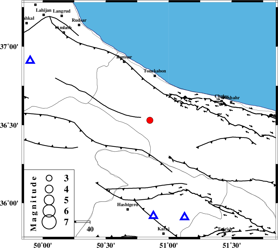
| Location | Lat:36.53 Lon: 50.85 |
| Region | Mazandaran Province, 32 km South of Tonekabon |
Nearest Cities |
|
| 24 km South West of Kanza, Mazandaran Province | |
| 29 km South of Khorramabad, Mazandaran Province | |
| 30 km South of Soleymanabad, Mazandaran Province | |
| 31 km South West of Abbasabad, Mazandaran Province | |
| 32 km South of Tonekabon, Mazandaran Province | |
| Depth | 35 km |
| Agency | |
Faults within 150 km: |
|
| BONAN_F (Length: 74 km) , Distance to epicenter: 7 km | |
| N_ALBORZ_F (Length: 360 km) , Distance to epicenter: 21 km | |
| KHAZAR_F (Length: 523 km) , Distance to epicenter: 21 km | |
| Number of Phases | 5 |
| RMS | 0.1 |
| Number of Stations | 5 |
| Error in Latitude | >3.4 km |
| Error in Longitude | 3.1 km |
| Error in Depth | 9.2 km |
Download waveform in seisan format
to download seisan software Click here
to access information about IIEES stations Click here
Amplitude | ||||||||
| UID | Agency | Station | Component | Amplitude | Period | Arrival Time | Proccessing Time | Signal Clip |
| 69482 | IIEES | THKV | E | 2687.1 | 0.44 | 2010-08-20 03:12:19 | 2010-08-29 12:45:00 | n |
| 69483 | IIEES | THKV | N | 1954.5 | 0.48 | 2010-08-20 03:12:19 | 2010-08-29 12:45:00 | n |
| 69484 | IIEES | ZNJK | N | 206.5 | 0.28 | 2010-08-20 03:12:54 | 2010-08-29 12:45:00 | n |
| 69485 | IIEES | ZNJK | E | 136.5 | 0.64 | 2010-08-20 03:12:56 | 2010-08-29 12:45:00 | n |
| 69486 | IIEES | GHVR | E | 92.6 | 0.28 | 2010-08-20 03:13:08 | 2010-08-29 12:45:00 | n |
Phase | ||||||||||||
| Agency | Station | Component | Phase Type | Phase Quality | First Motion | Observed Arrival Time | Time Residual | Loc. Flag | Input Weight | Distance | Azimuth | |
| IIEES | THKV | Z | Pg | E | 2010-08-20 03:12:08 | 0 | y | 68.4 | 178 | |||
| IIEES | DAMV | Z | Pg | E | 2010-08-20 03:12:19 | 0 | y | 142 | 134 | |||
| IIEES | ZNJK | Z | Pg | E | 2010-08-20 03:12:27 | 0 | y | 194 | 275 | |||
| IIEES | GHVR | Z | Pg | E | 2010-08-20 03:12:32 | -0.1 | y | 230 | 171 | |||
| IIEES | ASAO | Z | Pg | E | 2010-08-20 03:12:33 | 0.1 | y | 232 | 199 | |||