
Magnitude |
:2.9 |
| Date & Time (UTC) | 2010-08-19 03:21:35.4 |
| Date & Time (Local) | 1389/5/28 07:51:35.4 |
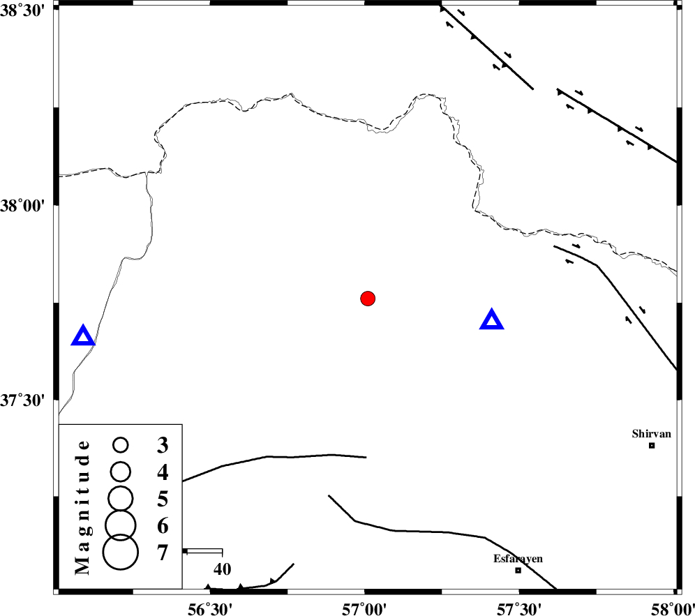
| Location | Lat:37.76 Lon: 57.01 |
| Region | Khorasan(north) Province, 24 km North of Ashkhaneh |
Nearest Cities |
|
| 12 km North of Pish qaleh, Khorasan(north) Province | |
| 22 km South West of Raz, Khorasan(north) Province | |
| 22 km South of Tangehzar, Khorasan(north) Province | |
| 24 km North of Ashkhaneh, Khorasan(north) Province | |
| 43 km North West of Void, Khorasan(north) Province | |
| Depth | 14 km |
| Agency | |
Faults within 150 km: |
|
| ROBATE_QARABIL_F (Length: 168 km) , Distance to epicenter: 45 km | |
| BAGHAN_GERMAB_F (Length: 79 km) , Distance to epicenter: 55 km | |
| ESFARAYEN_F (Length: 111 km) , Distance to epicenter: 57 km | |
| Number of Phases | 6 |
| RMS | 0.2 |
| Number of Stations | 4 |
| Error in Latitude | >3.4 km |
| Error in Longitude | 2.2 km |
| Error in Depth | 5.3 km |
Download waveform in seisan format
to download seisan software Click here
to access information about IIEES stations Click here
Amplitude | ||||||||
| UID | Agency | Station | Component | Amplitude | Period | Arrival Time | Proccessing Time | Signal Clip |
| 69471 | IIEES | BJRD | E | 1571.1 | 0.16 | 2010-08-19 03:21:47 | 2010-08-29 12:45:00 | n |
| 69472 | IIEES | BJRD | N | 3002.4 | 0.4 | 2010-08-19 03:21:47 | 2010-08-29 12:45:00 | n |
| 69473 | IIEES | MRVT | N | 290.8 | 0.52 | 2010-08-19 03:22:05 | 2010-08-29 12:45:00 | n |
| 69474 | IIEES | MRVT | E | 382 | 0.36 | 2010-08-19 03:22:05 | 2010-08-29 12:45:00 | n |
Phase | ||||||||||||
| Agency | Station | Component | Phase Type | Phase Quality | First Motion | Observed Arrival Time | Time Residual | Loc. Flag | Input Weight | Distance | Azimuth | |
| IIEES | BJRD | Z | Pg | E | 2010-08-19 03:21:42 | 0 | y | 36.1 | 101 | |||
| IIEES | BJRD | N | Sg | E | 2010-08-19 03:21:47 | 0 | y | 36.1 | 101 | |||
| IIEES | MRVT | Z | Pg | E | 2010-08-19 03:21:49 | -0.1 | y | 81.6 | 262 | |||
| IIEES | SHRO | Z | Pn | E | 2010-08-19 03:22:10 | 0.3 | y | 214 | 205 | |||
| IIEES | SHRO | N | Sg | E | 2010-08-19 03:22:35 | -0.1 | y | 214 | 205 | |||
| IIEES | TABS | Z | Pn | E | 2010-08-19 03:22:39 | 0 | y | 456 | 179 | |||