
Magnitude |
:3.4 |
| Date & Time (UTC) | 2010-08-17 15:59:35.4 |
| Date & Time (Local) | 1389/5/26 20:29:35.4 |
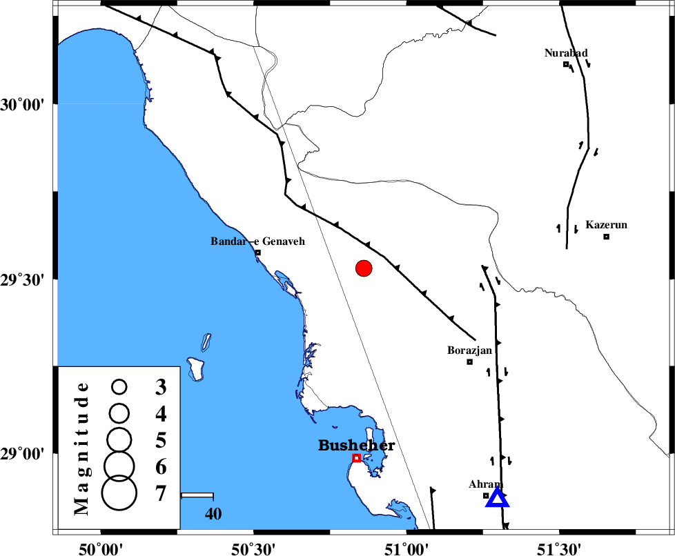
| Location | Lat:29.53 Lon: 50.86 |
| Region | Bushehr Province, 34 km East of Bandar-e genaveh |
Nearest Cities |
|
| 8 km of Chehar rustaee, Bushehr Province | |
| 14 km North West of Dehkohneh, Bushehr Province | |
| 23 km North East of Bandarehrig, Bushehr Province | |
| 27 km South East of Mohammad salehi, Bushehr Province | |
| 28 km North West of Shabankareh, Bushehr Province | |
| Depth | 25 km |
| Agency | |
Faults within 150 km: |
|
| ZFF3 (Length: 125 km) , Distance to epicenter: 7 km | |
| BORAZJAN_F (Length: 168 km) , Distance to epicenter: 37 km | |
| KAZERUN_F (Length: 96 km) , Distance to epicenter: 65 km | |
| Number of Phases | 6 |
| RMS | 0 |
| Number of Stations | 6 |
| Error in Latitude | >3.1 km |
| Error in Longitude | 4.4 km |
| Error in Depth | 5.2 km |
Download waveform in seisan format
to download seisan software Click here
to access information about IIEES stations Click here
Amplitude | ||||||||
| UID | Agency | Station | Component | Amplitude | Period | Arrival Time | Proccessing Time | Signal Clip |
| 69413 | IIEES | GHIR | E | 140.8 | 0.48 | 2010-08-17 16:01:06 | 2010-08-29 12:45:00 | n |
| 69414 | IIEES | KRBR | N | 36.3 | 1.06 | 2010-08-17 16:01:57 | 2010-08-29 12:45:00 | n |
| 69415 | IIEES | KRBR | E | 28.1 | 2.56 | 2010-08-17 16:02:00 | 2010-08-29 12:45:00 | n |
Phase | ||||||||||||
| Agency | Station | Component | Phase Type | Phase Quality | First Motion | Observed Arrival Time | Time Residual | Loc. Flag | Input Weight | Distance | Azimuth | |
| IIEES | AHRM | Z | Pg | E | 2010-08-17 15:59:49 | 0 | y | 84.7 | 150 | |||
| IIEES | GHIR | Z | PN5 | E | 2010-08-17 16:00:13 | 0 | y | 249 | 123 | |||
| IIEES | NASN | Z | Pn | E | 2010-08-17 16:00:33 | 0 | y | 408 | 27 | |||
| IIEES | KHMZ | Z | Pn | E | 2010-08-17 16:00:41 | 0.1 | y | 475 | 350 | |||
| IIEES | KRBR | Z | Pn | E | 2010-08-17 16:00:53 | 0 | y | 573 | 83 | |||
| IIEES | SNGE | Z | Pn | E | 2010-08-17 16:01:09 | 0 | y | 700 | 333 | |||