
Magnitude |
:3.2 |
| Date & Time (UTC) | 2010-08-15 01:48:48.7 |
| Date & Time (Local) | 1389/5/24 06:18:48.7 |
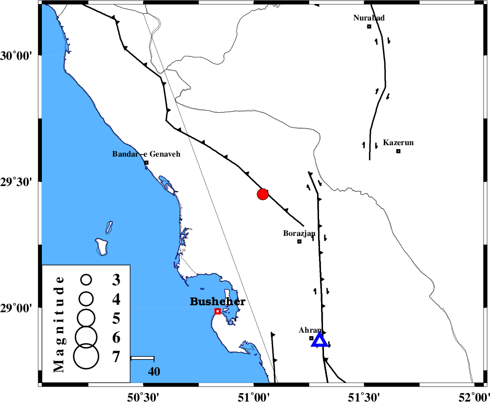
| Location | Lat:29.45 Lon: 51.04 |
| Region | Bushehr Province, 26 km North-West of Borazjan |
Nearest Cities |
|
| 5 km of Dehkohneh, Bushehr Province | |
| 11 km North of Saedabad, Bushehr Province | |
| 16 km North West of Nazar aqa, Bushehr Province | |
| 19 km North of Shabankareh, Bushehr Province | |
| 19 km North of Ziyarat, Bushehr Province | |
| Depth | 18 km |
| Agency | |
Faults within 150 km: |
|
| ZFF3 (Length: 125 km) , Distance to epicenter: 1 km | |
| BORAZJAN_F (Length: 168 km) , Distance to epicenter: 22 km | |
| KAZERUN_F (Length: 96 km) , Distance to epicenter: 49 km | |
| Number of Phases | 4 |
| RMS | 0.1 |
| Number of Stations | 3 |
| Error in Latitude | >5.2 km |
| Error in Longitude | 8.2 km |
| Error in Depth | 14.9 km |
Download waveform in seisan format
to download seisan software Click here
to access information about IIEES stations Click here
Amplitude | ||||||||
| UID | Agency | Station | Component | Amplitude | Period | Arrival Time | Proccessing Time | Signal Clip |
| 69410 | IIEES | GHIR | N | 410.5 | 0 | 2010-08-15 01:50:07 | 2010-08-29 12:45:00 | n |
| 69411 | IIEES | GHIR | E | 414.6 | 0.3 | 2010-08-15 01:50:09 | 2010-08-29 12:45:00 | n |
| 69412 | IIEES | NASN | N | 9.4 | 3.22 | 2010-08-15 01:50:35 | 2010-08-29 12:45:00 | n |
Phase | ||||||||||||
| Agency | Station | Component | Phase Type | Phase Quality | First Motion | Observed Arrival Time | Time Residual | Loc. Flag | Input Weight | Distance | Azimuth | |
| IIEES | AHRM | Z | Pg | E | 2010-08-15 01:49:00 | 0.1 | y | 69.5 | 159 | |||
| IIEES | AHRM | E | Sg | E | 2010-08-15 01:49:09 | -0.1 | y | 69.5 | 159 | |||
| IIEES | GHIR | Z | Pg | E | 2010-08-15 01:49:26 | 0 | y | 229 | 124 | |||
| IIEES | NASN | Z | Pn | E | 2010-08-15 01:49:46 | -0.1 | y | 407 | 24 | |||