
Magnitude |
:3 |
| Date & Time (UTC) | 2010-08-09 11:57:32.5 |
| Date & Time (Local) | 1389/5/18 16:27:32.5 |
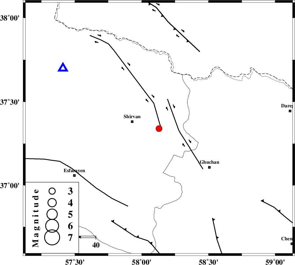
| Location | Lat:37.34 Lon: 58.13 |
| Region | Khorasan(north) Province, 19 km East of Shirvan |
Nearest Cities |
|
| 11 km East of Amirabad, Khorasan(north) Province | |
| 16 km North of Faruj, Khorasan(center) Province | |
| 16 km North West of Yatnakanlu, Khorasan(center) Province | |
| 17 km North of Maviyan, Khorasan(center) Province | |
| 18 km East of Shirvan, Khorasan(north) Province | |
| Depth | 35 km |
| Agency | |
Faults within 150 km: |
|
| BAGHAN_GERMAB_F (Length: 79 km) , Distance to epicenter: 1 km | |
| GHUCHAN_F (Length: 50 km) , Distance to epicenter: 13 km | |
| ESFARAYEN_F (Length: 111 km) , Distance to epicenter: 56 km | |
| Number of Phases | 5 |
| RMS | 0.2 |
| Number of Stations | 3 |
| Error in Latitude | >9.1 km |
| Error in Longitude | 8 km |
| Error in Depth | 8.5 km |
Download waveform in seisan format
to download seisan software Click here
to access information about IIEES stations Click here
Amplitude | ||||||||
| UID | Agency | Station | Component | Amplitude | Period | Arrival Time | Proccessing Time | Signal Clip |
| 68250 | IIEES | BJRD | E | 491.6 | 0.24 | 2010-08-09 11:57:58 | 2010-08-09 12:25:00 | n |
| 68251 | IIEES | MRVT | E | 134.7 | 0.28 | 2010-08-09 11:58:27 | 2010-08-09 12:25:00 | n |
| 68252 | IIEES | MRVT | N | 231.3 | 0.52 | 2010-08-09 11:58:33 | 2010-08-09 12:25:00 | n |
Phase | ||||||||||||
| Agency | Station | Component | Phase Type | Phase Quality | First Motion | Observed Arrival Time | Time Residual | Loc. Flag | Input Weight | Distance | Azimuth | |
| IIEES | BJRD | Z | Pg | E | 2010-08-09 11:57:45 | -0.2 | y | 75.4 | 302 | |||
| IIEES | BJRD | E | Sg | E | 2010-08-09 11:57:56 | 0.3 | y | 75.4 | 302 | |||
| IIEES | MRVT | Z | Pn | E | 2010-08-09 11:58:01 | 0 | y | 184 | 282 | |||
| IIEES | MRVT | N | Sg | E | 2010-08-09 11:58:24 | -0.2 | y | 184 | 282 | |||
| IIEES | SHRO | N | Pn | E | 2010-08-09 11:58:08 | 0.1 | y | 240 | 233 | |||