
Magnitude |
:3.7 |
| Date & Time (UTC) | 2010-08-08 09:39:02.1 |
| Date & Time (Local) | 1389/5/17 14:09:02.1 |
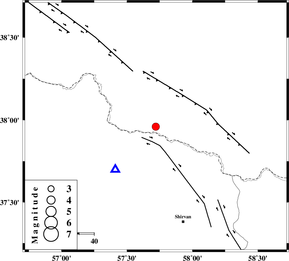
| Location | Lat:37.96 Lon: 57.72 |
| Region | 58 km West of Ashgabat |
Nearest Cities |
|
| 22 km North East of Gifan olia, Khorasan(north) Province | |
| 24 km North of Yangi ghale-ye bala, Khorasan(north) Province | |
| 35 km North West of Kuseh, Khorasan(north) Province | |
| 37 km North of Tukur, Khorasan(north) Province | |
| 41 km North West of Lojali, Khorasan(north) Province | |
| Depth | 14 km |
| Agency | |
Faults within 150 km: |
|
| BAGHAN_GERMAB_F (Length: 79 km) , Distance to epicenter: 10 km | |
| MAIN_KOPEHDAGH_F3 (Length: 96 km) , Distance to epicenter: 28 km | |
| MAIN_KOPEHDAGH_F2 (Length: 131 km) , Distance to epicenter: 40 km | |
| Number of Phases | 6 |
| RMS | 0.1 |
| Number of Stations | 3 |
| Error in Latitude | >3 km |
| Error in Longitude | 5.4 km |
| Error in Depth | 7.1 km |
Download waveform in seisan format
to download seisan software Click here
to access information about IIEES stations Click here
Amplitude | ||||||||
| UID | Agency | Station | Component | Amplitude | Period | Arrival Time | Proccessing Time | Signal Clip |
| 68090 | IIEES | BJRD | E | 12391 | 0.46 | 2010-08-08 09:39:16 | 2010-08-08 09:52:00 | n |
| 68091 | IIEES | MRVT | N | 1357.9 | 0.52 | 2010-08-08 09:39:50 | 2010-08-08 09:52:00 | n |
| 68092 | IIEES | MRVT | E | 972.8 | 0.52 | 2010-08-08 09:39:50 | 2010-08-08 09:52:00 | n |
Phase | ||||||||||||
| Agency | Station | Component | Phase Type | Phase Quality | First Motion | Observed Arrival Time | Time Residual | Loc. Flag | Input Weight | Distance | Azimuth | |
| IIEES | BJRD | Z | Pg | E | 2010-08-08 09:39:09 | -0.1 | y | 40.1 | 223 | |||
| IIEES | BJRD | N | Sg | E | 2010-08-08 09:39:15 | 0.1 | y | 40.1 | 223 | |||
| IIEES | MRVT | Z | Pg | E | 2010-08-08 09:39:26 | -0.1 | y | 148 | 257 | |||
| IIEES | MRVT | E | Sg | E | 2010-08-08 09:39:44 | 0.1 | y | 148 | 257 | |||
| IIEES | SHRO | Z | Pn | E | 2010-08-08 09:39:42 | 0.2 | y | 265 | 216 | |||
| IIEES | SHRO | N | Sg | E | 2010-08-08 09:40:16 | -0.1 | y | 265 | 216 | |||