
Magnitude |
:2.9 |
| Date & Time (UTC) | 2010-07-30 17:16:24.8 |
| Date & Time (Local) | 1389/5/8 21:46:24.8 |
| Location | Lat:32.94 Lon: 47.91 |
| Region | Lorestan Province, 30 km South-East of Pol-e dokhtar |
Nearest Cities |
|
| 27 km South East of Sarab hammam, Lorestan Province | |
| 30 km South East of Pol-e dokhtar, Lorestan Province | |
| 32 km North East of Sarabbagh, Ilam Province | |
| 37 km North West of Bidruyeh, Khoozestan Province | |
| 38 km South East of Morani, Lorestan Province | |
| Depth | 46 km |
| Agency | |
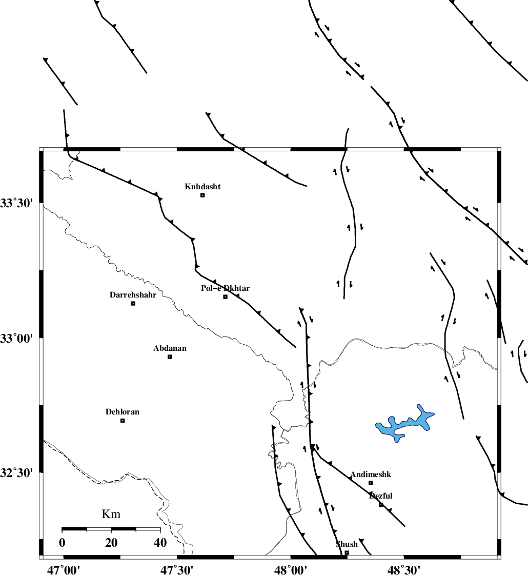
Faults within 150 km: |
|
| BALARUD_F_Z1 (Length: 87 km) , Distance to epicenter: 17 km | |
| BALARUD_F_Z3 (Length: 53 km) , Distance to epicenter: 17 km | |
| MFF6 (Length: 144 km) , Distance to epicenter: 41 km | |
| Number of Phases | 4 |
| RMS | 0.1 |
| Number of Stations | 3 |
| Error in Latitude | >15.6 km |
| Error in Longitude | 9.1 km |
| Error in Depth | 53.8 km |
Download waveform in seisan format
to download seisan software Click here
to access information about IIEES stations Click here
Amplitude | ||||||||
| UID | Agency | Station | Component | Amplitude | Period | Arrival Time | Proccessing Time | Signal Clip |
| 67170 | IIEES | KHMZ | E | 59.4 | 1.95 | 2010-07-30 17:17:29 | 2010-07-30 05:35:00 | n |
| 67171 | IIEES | KHMZ | N | 83.7 | 0.15 | 2010-07-30 17:17:30 | 2010-07-30 05:35:00 | n |
| 67172 | IIEES | SNGE | N | 79.4 | 0.88 | 2010-07-30 17:17:42 | 2010-07-30 05:35:00 | n |
| 67173 | IIEES | SNGE | E | 76.5 | 0.78 | 2010-07-30 17:17:44 | 2010-07-30 05:35:00 | n |
| 67174 | IIEES | ASAO | E | 57.5 | 0.59 | 2010-07-30 17:17:43 | 2010-07-30 05:35:00 | n |
| 67175 | IIEES | ASAO | N | 56.3 | 0.82 | 2010-07-30 17:17:44 | 2010-07-30 05:35:00 | n |
Phase | ||||||||||||
| Agency | Station | Component | Phase Type | Phase Quality | First Motion | Observed Arrival Time | Time Residual | Loc. Flag | Input Weight | Distance | Azimuth | |
| IIEES | KHMZ | Z | Pg | E | 2010-07-30 17:16:59 | 0.1 | y | 211 | 65 | |||
| IIEES | KHMZ | E | Sg | E | 2010-07-30 17:17:24 | 0 | y | 211 | 65 | |||
| IIEES | SNGE | Z | Pg | E | 2010-07-30 17:17:04 | 0.1 | y | 244 | 348 | |||
| IIEES | ASAO | Z | Pg | E | 2010-07-30 17:17:07 | -0.2 | y | 265 | 47 | |||