
Magnitude |
:3 |
| Date & Time (UTC) | 2010-07-21 18:02:29.6 |
| Date & Time (Local) | 1389/4/30 22:32:29.6 |
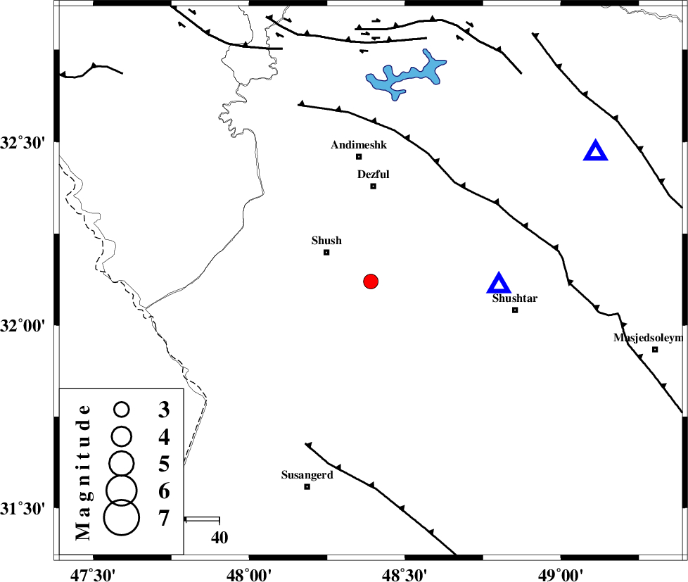
| Location | Lat:32.12 Lon: 48.39 |
| Region | Khoozestan Province, 16 km East of Shush |
Nearest Cities |
|
| 12 km East of Amaleh teimur, Khoozestan Province | |
| 16 km East of Shush, Khoozestan Province | |
| 20 km South of Shamsabad, Khoozestan Province | |
| 29 km South of Dezful, Khoozestan Province | |
| 33 km North of Abdolkhan-eali, Khoozestan Province | |
| Depth | 18 km |
| Agency | |
Faults within 150 km: |
|
| DEZFUL_EMBAYMENT (Length: 228 km) , Distance to epicenter: 39 km | |
| AHVAZ_F (Length: 99 km) , Distance to epicenter: 53 km | |
| BALARUD_F_Z3 (Length: 53 km) , Distance to epicenter: 72 km | |
| Number of Phases | 4 |
| RMS | 0 |
| Number of Stations | 3 |
| Error in Latitude | >4.6 km |
| Error in Longitude | 8.9 km |
| Error in Depth | 12.3 km |
Download waveform in seisan format
to download seisan software Click here
to access information about IIEES stations Click here
Amplitude | ||||||||
| UID | Agency | Station | Component | Amplitude | Period | Arrival Time | Proccessing Time | Signal Clip |
| 66330 | IIEES | SHGR | N | 2235.6 | 0.29 | 2010-07-21 18:02:51 | 2010-07-21 06:20:00 | n |
| 66331 | IIEES | SHGR | E | 2879.9 | 0.07 | 2010-07-21 18:02:52 | 2010-07-21 06:20:00 | n |
| 66332 | IIEES | KHMZ | E | 110.4 | 0.85 | 2010-07-21 18:03:42 | 2010-07-21 06:20:00 | n |
| 66333 | IIEES | KHMZ | N | 77 | 0.85 | 2010-07-21 18:03:49 | 2010-07-21 06:20:00 | n |
| 66334 | IIEES | SNGE | E | 23.3 | 1.49 | 2010-07-21 18:04:28 | 2010-07-21 06:20:00 | n |
Phase | ||||||||||||
| Agency | Station | Component | Phase Type | Phase Quality | First Motion | Observed Arrival Time | Time Residual | Loc. Flag | Input Weight | Distance | Azimuth | |
| IIEES | SHGR | Z | Pg | E | 2010-07-21 18:02:36 | 0 | y | 38.5 | 92 | |||
| IIEES | SHGR | E | Sg | E | 2010-07-21 18:02:42 | 0 | y | 38.5 | 92 | |||
| IIEES | KHMZ | Z | Pg | E | 2010-07-21 18:03:07 | 0 | y | 232 | 39 | |||
| IIEES | SNGE | Z | Pn | E | 2010-07-21 18:03:19 | 0 | y | 344 | 344 | |||