
Magnitude |
:3.2 |
| Date & Time (UTC) | 2010-07-09 14:37:02.9 |
| Date & Time (Local) | 1389/4/18 19:07:02.9 |
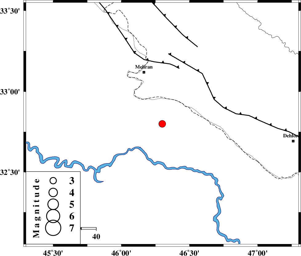
| Location | Lat:32.8 Lon: 46.3 |
| Region | Iraq, 37 km South-East of Mehran |
Nearest Cities |
|
| 38 km South East of Mehran, Ilam Province | |
| 55 km South West of Gonbad-e pirmohammad, Ilam Province | |
| 61 km South West of Galeh-yedarre-hemalakshahi, Ilam Province | |
| 63 km West of Bishehzar, Ilam Province | |
| 73 km South West of Mehr, Ilam Province | |
| Depth | 14 km |
| Agency | |
Faults within 150 km: |
|
| MFF6 (Length: 144 km) , Distance to epicenter: 39 km | |
| ZFF4 (Length: 128 km) , Distance to epicenter: 40 km | |
| MFF7 (Length: 99 km) , Distance to epicenter: 58 km | |
| Number of Phases | 6 |
| RMS | 0.1 |
| Number of Stations | 4 |
| Error in Latitude | >3 km |
| Error in Longitude | 6.1 km |
| Error in Depth | 6.5 km |
Download waveform in seisan format
to download seisan software Click here
to access information about IIEES stations Click here
Amplitude | ||||||||
| UID | Agency | Station | Component | Amplitude | Period | Arrival Time | Proccessing Time | Signal Clip |
| 65885 | IIEES | SHGR | E | 185.6 | 0.48 | 2010-07-09 14:38:30 | 2010-07-14 10:36:00 | n |
| 65886 | IIEES | SHGR | N | 185.5 | 0.6 | 2010-07-09 14:38:30 | 2010-07-14 10:36:00 | n |
| 65887 | IIEES | SNGE | E | 109.4 | 0.68 | 2010-07-09 14:38:21 | 2010-07-14 10:36:00 | n |
| 65888 | IIEES | SNGE | N | 96.1 | 0.64 | 2010-07-09 14:38:29 | 2010-07-14 10:36:00 | n |
Phase | ||||||||||||
| Agency | Station | Component | Phase Type | Phase Quality | First Motion | Observed Arrival Time | Time Residual | Loc. Flag | Input Weight | Distance | Azimuth | |
| IIEES | SHGR | Z | Pn | E | 2010-07-09 14:37:41 | -0.2 | y | 248 | 107 | |||
| IIEES | SNGE | Z | Pn | E | 2010-07-09 14:37:44 | 0.1 | y | 272 | 21 | |||
| IIEES | SNGE | N | Sg | E | 2010-07-09 14:38:19 | -0.1 | y | 272 | 21 | |||
| IIEES | KHMZ | Z | Pn | E | 2010-07-09 14:37:55 | 0.2 | y | 357 | 72 | |||
| IIEES | KHMZ | N | Sn | 2010-07-09 14:38:33 | 0 | y | 357 | 72 | ||||
| IIEES | ASAO | Z | Pn | E | 2010-07-09 14:37:59 | -0.1 | y | 396 | 60 | |||