
Magnitude |
:2.6 |
| Date & Time (UTC) | 2010-07-05 07:25:00.6 |
| Date & Time (Local) | 1389/4/14 11:55:00.6 |
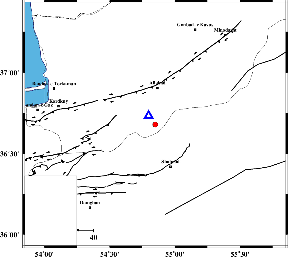
| Location | Lat:36.68 Lon: 54.85 |
| Region | Golestan Province, 25 km South of Ali Abad |
Nearest Cities |
|
| 23 km North West of Qaleh-ye nokharqan, Semnan Province | |
| 25 km South of Ali Abad, Golestan Province | |
| 26 km North West of Bastam, Semnan Province | |
| 29 km North East of Majen, Semnan Province | |
| 31 km North West of Shahrud, Semnan Province | |
| Depth | 14 km |
| Agency | |
Faults within 150 km: |
|
| SHAVAR_F (Length: 87 km) , Distance to epicenter: 13 km | |
| ASTANEH_F (Length: 72 km) , Distance to epicenter: 31 km | |
| KHAZAR_F (Length: 523 km) , Distance to epicenter: 36 km | |
| Number of Phases | 6 |
| RMS | 0.2 |
| Number of Stations | 4 |
| Error in Latitude | >2.9 km |
| Error in Longitude | 7.9 km |
| Error in Depth | 6.7 km |
Download waveform in seisan format
to download seisan software Click here
to access information about IIEES stations Click here
Amplitude | ||||||||
| UID | Agency | Station | Component | Amplitude | Period | Arrival Time | Proccessing Time | Signal Clip |
| 65432 | IIEES | MRVT | N | 82.2 | 0.21 | 2010-07-05 07:25:47 | 2010-07-06 09:37:00 | n |
| 65433 | IIEES | MRVT | E | 96.8 | 0.27 | 2010-07-05 07:25:48 | 2010-07-06 09:37:00 | n |
| 65434 | IIEES | TABS | N | 12.2 | 0.66 | 2010-07-05 07:27:04 | 2010-07-06 09:37:00 | n |
Phase | ||||||||||||
| Agency | Station | Component | Phase Type | Phase Quality | First Motion | Observed Arrival Time | Time Residual | Loc. Flag | Input Weight | Distance | Azimuth | |
| IIEES | SHRO | Z | Pg | E | 2010-07-05 07:25:22 | -0.1 | y | 128 | 125 | |||
| IIEES | MRVT | Z | Pg | E | 2010-07-05 07:25:26 | -0.3 | y | 154 | 45 | |||
| IIEES | MRVT | N | Sg | E | 2010-07-05 07:25:45 | 0.1 | y | 154 | 45 | |||
| IIEES | BJRD | Z | Pn | E | 2010-07-05 07:25:40 | 0.2 | y | 254 | 63 | |||
| IIEES | BJRD | N | Sg | E | 2010-07-05 07:26:12 | 0 | y | 254 | 63 | |||
| IIEES | TABS | Z | Pn | E | 2010-07-05 07:25:57 | 0.1 | y | 395 | 148 | |||