
Magnitude |
:2.8 |
| Date & Time (UTC) | 2010-06-17 01:51:45.7 |
| Date & Time (Local) | 1389/3/27 06:21:45.7 |
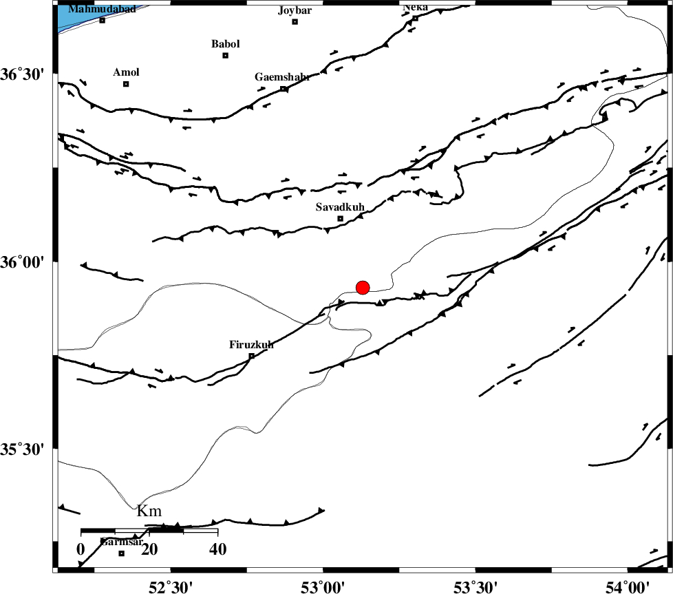
| Location | Lat:35.93 Lon: 53.13 |
| Region | Mazandaran Province, 21 km South of Pol-E-Sefid |
Nearest Cities |
|
| 13 km North West of Chashem, Semnan Province | |
| 18 km South of Sangdeh, Mazandaran Province | |
| 19 km South of Shurmast-e peyrudbar, Mazandaran Province | |
| 21 km South of Pol-E-Sefid, Mazandaran Province | |
| 23 km South East of Elahband, Mazandaran Province | |
| Depth | 14 km |
| Agency | |
Faults within 150 km: |
|
| ATARI_F (Length: 185 km) , Distance to epicenter: 26 km | |
| N_ALBORZ_F (Length: 360 km) , Distance to epicenter: 31 km | |
| MOSHA_F (Length: 234 km) , Distance to epicenter: 51 km | |
| Number of Phases | 7 |
| RMS | 0.2 |
| Number of Stations | 6 |
| Error in Latitude | >5.1 km |
| Error in Longitude | 4.2 km |
| Error in Depth | 8.4 km |
Download waveform in seisan format
to download seisan software Click here
to access information about IIEES stations Click here
Amplitude | ||||||||
| UID | Agency | Station | Component | Amplitude | Period | Arrival Time | Proccessing Time | Signal Clip |
| 64573 | IIEES | GHVR | E | 96.9 | 0.64 | 2010-06-17 01:52:59 | 2010-06-19 09:34:00 | n |
| 64574 | IIEES | GHVR | N | 60.3 | 0.4 | 2010-06-17 01:53:05 | 2010-06-19 09:34:00 | n |
| 64575 | IIEES | ASAO | N | 17.9 | 0.7 | 2010-06-17 01:53:17 | 2010-06-19 09:34:00 | n |
Phase | ||||||||||||
| Agency | Station | Component | Phase Type | Phase Quality | First Motion | Observed Arrival Time | Time Residual | Loc. Flag | Input Weight | Distance | Azimuth | |
| IIEES | GHVR | Z | Pg | E | 2010-06-17 01:52:23 | -0.3 | y | 235 | 227 | |||
| IIEES | GHVR | E | Sg | E | 2010-06-17 01:52:52 | 0.2 | y | 235 | 227 | |||
| IIEES | SHRO | Z | Pn | E | 2010-06-17 01:52:25 | 0 | y | 260 | 87 | |||
| IIEES | ASAO | Z | Pn | E | 2010-06-17 01:52:33 | 0 | y | 322 | 242 | |||
| IIEES | MRVT | Z | Pn | E | 2010-06-17 01:52:33 | -0.1 | y | 326 | 53 | |||
| IIEES | BJRD | Z | Pn | E | 2010-06-17 01:52:46 | 0.2 | y | 429 | 62 | |||
| IIEES | TABS | Z | Pn | E | 2010-06-17 01:52:48 | -0.1 | y | 444 | 124 | |||