
Magnitude |
:2.9 |
| Date & Time (UTC) | 2010-06-12 10:28:46.7 |
| Date & Time (Local) | 1389/3/22 14:58:46.7 |
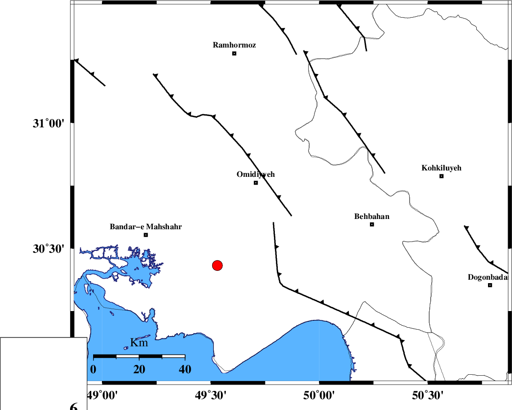
| Location | Lat:30.72 Lon: 49.87 |
| Region | Khoozestan Province, 16 km East of Omidiyeh |
Nearest Cities |
|
| 4 km North of Aghajari, Khoozestan Province | |
| 11 km of Jolaki, Khoozestan Province | |
| 12 km East of Chah-e salem, Khoozestan Province | |
| 16 km East of Omidiyeh, Khoozestan Province | |
| 17 km North of Asiyab, Khoozestan Province | |
| Depth | 30 km |
| Agency | |
Faults within 150 km: |
|
| AGHAJARI_F (Length: 88 km) , Distance to epicenter: 10 km | |
| RAG_E_SEFID_F (Length: 84 km) , Distance to epicenter: 15 km | |
| MFF4 (Length: 62 km) , Distance to epicenter: 40 km | |
| Number of Phases | 5 |
| RMS | 0.2 |
| Number of Stations | 6 |
| Error in Latitude | >5.3 km |
| Error in Longitude | 8.5 km |
| Error in Depth | 9.6 km |
Download waveform in seisan format
to download seisan software Click here
to access information about IIEES stations Click here
Amplitude | ||||||||
| UID | Agency | Station | Component | Amplitude | Period | Arrival Time | Proccessing Time | Signal Clip |
| 64177 | IIEES | SHGR | N | 270.4 | 0.47 | 2010-06-12 10:29:47 | 2010-06-13 09:48:00 | n |
| 64178 | IIEES | GHIR | E | 18 | 0.67 | 2010-06-12 10:31:03 | 2010-06-13 09:48:00 | n |
| 64179 | IIEES | GHVR | E | 11.2 | 0.62 | 2010-06-12 10:31:00 | 2010-06-13 09:48:00 | n |
Phase | ||||||||||||
| Agency | Station | Component | Phase Type | Phase Quality | First Motion | Observed Arrival Time | Time Residual | Loc. Flag | Input Weight | Distance | Azimuth | |
| IIEES | SHGR | Z | Pg | E | 2010-06-12 10:29:16 | 0 | y | 185 | 327 | |||
| IIEES | NASN | Z | Pn | E | 2010-06-12 10:29:37 | -0.2 | y | 362 | 50 | |||
| IIEES | GHIR | Z | PN5 | E | 2010-06-12 10:29:43 | 0 | y | 405 | 131 | |||
| IIEES | ASAO | Z | Pn | E | 2010-06-12 10:29:46 | 0.3 | y | 425 | 2 | |||
| IIEES | SNGE | Z | Pn | E | 2010-06-12 10:29:59 | -0.2 | y | 539 | 335 | |||