
Magnitude |
:3.2 |
| Date & Time (UTC) | 2010-04-30 18:41:38.3 |
| Date & Time (Local) | 1389/2/10 23:11:38.3 |
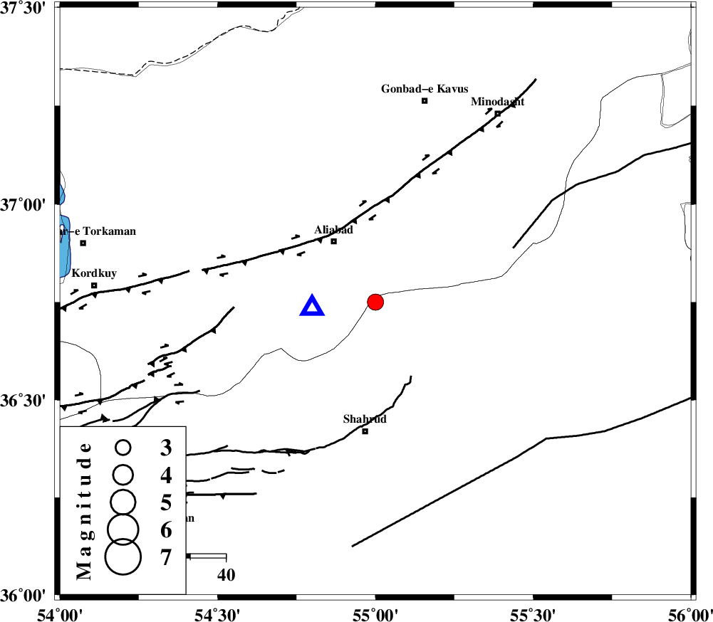
| Location | Lat:36.75 Lon: 55 |
| Region | Semnan Province, 21 km South-East of Ali Abad |
Nearest Cities |
|
| 16 km North West of Qaleh-ye nokharqan, Semnan Province | |
| 21 km South East of Ali Abad, Golestan Province | |
| 29 km South of Khanbebin, Golestan Province | |
| 29 km North West of Kalateh khanj, Semnan Province | |
| 30 km North of Bastam, Semnan Province | |
| Depth | 14 km |
| Agency | |
Faults within 150 km: |
|
| SHAVAR_F (Length: 87 km) , Distance to epicenter: 8 km | |
| KHAZAR_F (Length: 523 km) , Distance to epicenter: 29 km | |
| ROBATE_QARABIL_F (Length: 168 km) , Distance to epicenter: 42 km | |
| Number of Phases | 7 |
| RMS | 0.2 |
| Number of Stations | 5 |
| Error in Latitude | >5.1 km |
| Error in Longitude | 4.2 km |
| Error in Depth | 7.6 km |
Download waveform in seisan format
to download seisan software Click here
to access information about IIEES stations Click here
Amplitude | ||||||||
| UID | Agency | Station | Component | Amplitude | Period | Arrival Time | Proccessing Time | Signal Clip |
| 61430 | IIEES | DAMV | E | 86.2 | 0.4 | 2010-04-30 18:43:09 | 2010-04-30 07:08:00 | n |
| 61431 | IIEES | DAMV | N | 71.7 | 0.48 | 2010-04-30 18:43:17 | 2010-04-30 07:08:00 | n |
| 61432 | IIEES | TABS | N | 49.4 | 0.64 | 2010-04-30 18:43:41 | 2010-04-30 07:08:00 | n |
Phase | ||||||||||||
| Agency | Station | Component | Phase Type | Phase Quality | First Motion | Observed Arrival Time | Time Residual | Loc. Flag | Input Weight | Distance | Azimuth | |
| IIEES | MRVT | Z | Pg | E | 2010-04-30 18:42:01 | -0.3 | y | 140 | 43 | |||
| IIEES | MRVT | N | Sg | E | 2010-04-30 18:42:18 | 0 | y | 140 | 43 | |||
| IIEES | BJRD | N | Pn | E | 2010-04-30 18:42:15 | 0.3 | y | 239 | 63 | |||
| IIEES | BJRD | N | Sg | E | 2010-04-30 18:42:45 | 0.1 | y | 239 | 63 | |||
| IIEES | DAMV | E | Sg | E | 2010-04-30 18:43:02 | 0.1 | y | 299 | 246 | |||
| IIEES | TABS | Z | Pn | E | 2010-04-30 18:42:34 | 0 | y | 394 | 150 | |||
| IIEES | NASN | Z | Pn | E | 2010-04-30 18:42:45 | -0.2 | y | 482 | 205 | |||