
Magnitude |
:4.2 |
| Date & Time (UTC) | 2010-04-13 21:58:02.9 |
| Date & Time (Local) | 1389/1/25 02:28:02.9 |
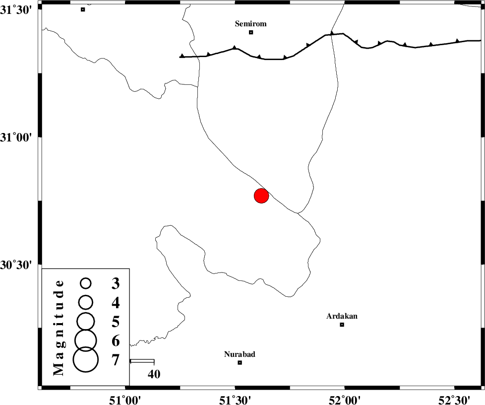
| Location | Lat:30.77 Lon: 51.62 |
| Region | Kohkiluieh va boyerahmad Province, 12 km Yasuj |
Nearest Cities |
|
| 12 km North of Yasuj, Kohkiluieh va boyerahmad Province | |
| 19 km North of Tal-e khosro, Kohkiluieh va boyerahmad Province | |
| 19 km East of Sisakht, Kohkiluieh va boyerahmad Province | |
| 20 km East of Kerik, Kohkiluieh va boyerahmad Province | |
| 22 km South West of Bideh, Esfahan Province | |
| Depth | 17 km |
| Agency | |
Faults within 150 km: |
|
| DENA_F (Length: 137 km) , Distance to epicenter: 2 km | |
| HZF3 (Length: 197 km) , Distance to epicenter: 8 km | |
| KAZERUN_F (Length: 96 km) , Distance to epicenter: 30 km | |
| Number of Phases | 9 |
| RMS | 0.5 |
| Number of Stations | 9 |
| Error in Latitude | >5.8 km |
| Error in Longitude | 4.8 km |
| Error in Depth | 0 km |
Download waveform in seisan format
to download seisan software Click here
to access information about IIEES stations Click here
Amplitude | ||||||||
| UID | Agency | Station | Component | Amplitude | Period | Arrival Time | Proccessing Time | Signal Clip |
| 60410 | IIEES | GHIR | N | 1006.4 | 0.56 | 2010-04-13 21:59:42 | 2010-04-13 10:22:00 | n |
| 60411 | IIEES | SHGR | N | 668.8 | 0.56 | 2010-04-13 21:59:54 | 2010-04-13 10:22:00 | n |
| 60412 | IIEES | SHGR | E | 856.8 | 0.56 | 2010-04-13 22:00:07 | 2010-04-13 10:22:00 | n |
| 60413 | IIEES | GHIR | E | 1239.3 | 0.56 | 2010-04-13 21:59:46 | 2010-04-13 10:22:00 | n |
Phase | ||||||||||||
| Agency | Station | Component | Phase Type | Phase Quality | First Motion | Observed Arrival Time | Time Residual | Loc. Flag | Input Weight | Distance | Azimuth | |
| IIEES | NASN | Z | Pn | E | 2010-04-13 21:58:41 | 0.1 | y | 252 | 26 | |||
| IIEES | SHGR | Z | Pn | E | 2010-04-13 21:58:48 | 0.5 | y | 306 | 300 | |||
| IIEES | GHIR | Z | Pn | E | 2010-04-13 21:58:48 | 0.1 | y | 306 | 154 | |||
| IIEES | GHVR | Z | Pn | E | 2010-04-13 21:59:02 | 0.5 | y | 413 | 355 | |||
| IIEES | DAMV | Z | Pn | E | 2010-04-13 21:59:17 | -0.7 | y | 540 | 3 | |||
| IIEES | CHTH | Z | Pn | E | 2010-04-13 21:59:21 | -0.6 | y | 572 | 356 | |||
| IIEES | BNDS | Z | Pn | E | 2010-04-13 21:59:21 | -0.5 | y | 580 | 129 | |||
| IIEES | TABS | Z | Pn | E | 2010-04-13 21:59:26 | 0.8 | y | 609 | 57 | |||
| IIEES | SNGE | Z | Pn | E | 2010-04-13 21:59:27 | -0.8 | y | 624 | 321 | |||