
Magnitude |
:3.8 |
| Date & Time (UTC) | 2010-04-09 21:21:56.0 |
| Date & Time (Local) | 1389/1/21 01:51:56.0 |
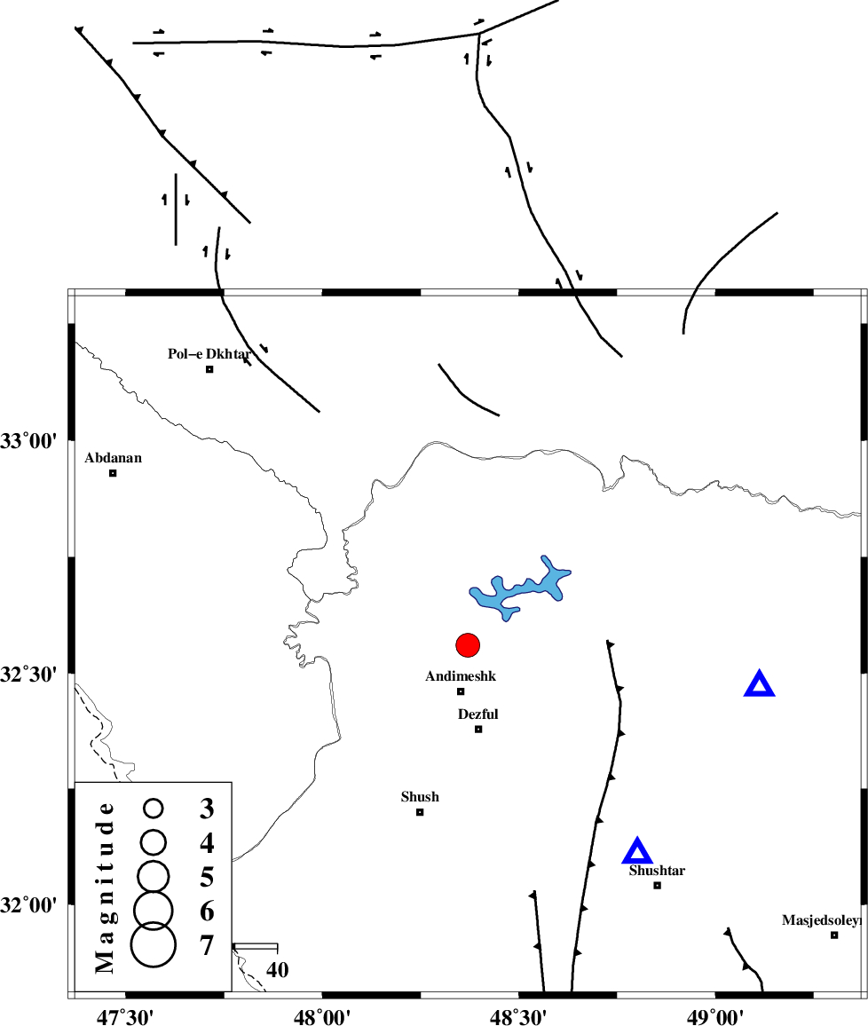
| Location | Lat:32.56 Lon: 48.37 |
| Region | Khoozestan Province, 11 km North of Andimeshk |
Nearest Cities |
|
| 11 km North of Andimeshk, Khoozestan Province | |
| 18 km South East of Hoseinieh, Khoozestan Province | |
| 20 km North of Dezful, Khoozestan Province | |
| 24 km South of Sorkhakan, Khoozestan Province | |
| 25 km South East of Bidruyeh, Khoozestan Province | |
| Depth | 16 km |
| Agency | |
Faults within 150 km: |
|
| DEZFUL_EMBAYMENT (Length: 228 km) , Distance to epicenter: 5 km | |
| BALARUD_F_Z3 (Length: 53 km) , Distance to epicenter: 23 km | |
| BALARUD_F_Z2 (Length: 58 km) , Distance to epicenter: 28 km | |
| Number of Phases | 7 |
| RMS | 0.3 |
| Number of Stations | 6 |
| Error in Latitude | >4 km |
| Error in Longitude | 8.9 km |
| Error in Depth | 10.3 km |
Download waveform in seisan format
to download seisan software Click here
to access information about IIEES stations Click here
Amplitude | ||||||||
| UID | Agency | Station | Component | Amplitude | Period | Arrival Time | Proccessing Time | Signal Clip |
| 60130 | IIEES | SNGE | E | 243.1 | 0.6 | 2010-04-09 21:23:23 | 2010-04-09 09:43:00 | n |
| 60131 | IIEES | GHVR | N | 342.3 | 0.76 | 2010-04-09 21:23:42 | 2010-04-09 09:43:00 | n |
| 60132 | IIEES | GHVR | E | 283.6 | 0.68 | 2010-04-09 21:23:44 | 2010-04-09 09:43:00 | n |
| 60133 | IIEES | NASN | N | 129.4 | 0.36 | 2010-04-09 21:23:42 | 2010-04-09 09:43:00 | n |
| 60134 | IIEES | NASN | E | 138.6 | 0.56 | 2010-04-09 21:24:02 | 2010-04-09 09:43:00 | n |
Phase | ||||||||||||
| Agency | Station | Component | Phase Type | Phase Quality | First Motion | Observed Arrival Time | Time Residual | Loc. Flag | Input Weight | Distance | Azimuth | |
| IIEES | SHGR | Z | Pg | E | 2010-04-09 21:22:07 | 0 | y | 64.7 | 141 | |||
| IIEES | SNGE | Z | Pn | E | 2010-04-09 21:22:40 | 0.2 | y | 296 | 342 | |||
| IIEES | GHVR | Z | Pn | E | 2010-04-09 21:22:46 | 0.6 | y | 342 | 51 | |||
| IIEES | NASN | Z | Pn | E | 2010-04-09 21:22:55 | -0.2 | y | 417 | 85 | |||
| IIEES | CHTH | E | Pn | E | 2010-04-09 21:22:59 | -0.4 | y | 450 | 34 | |||
| IIEES | CHTH | E | Sg | E | 2010-04-09 21:24:01 | 0 | y | 450 | 34 | |||
| IIEES | ZNJK | Z | Pn | E | 2010-04-09 21:23:00 | -0.3 | y | 457 | 4 | |||