
Magnitude |
:3.4 |
| Date & Time (UTC) | 2009-12-09 01:49:12.1 |
| Date & Time (Local) | 1388/9/18 05:19:12.1 |
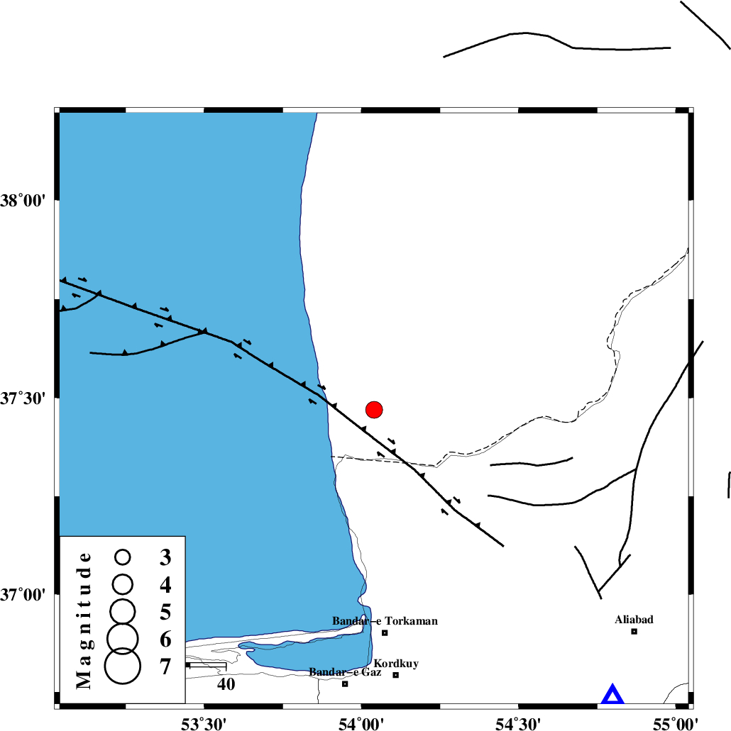
| Location | Lat:37.47 Lon: 54.04 |
| Region | 63 km North of Bandar-e torkaman |
Nearest Cities |
|
| 42 km North of Gomishtappeh, Golestan Province | |
| 54 km North West of Banavar, Golestan Province | |
| 61 km North West of Enchehborun, Golestan Province | |
| 63 km North West of Aq Qaleh, Golestan Province | |
| 63 km North of Bandar-e torkaman, Golestan Province | |
| Depth | 15 km |
| Agency | |
Faults within 150 km: |
|
| KHAZAR_F (Length: 523 km) , Distance to epicenter: 75 km | |
| N_ALBORZ_F (Length: 360 km) , Distance to epicenter: 101 km | |
| SHAVAR_F (Length: 87 km) , Distance to epicenter: 105 km | |
| Number of Phases | 5 |
| RMS | 0.4 |
| Number of Stations | 5 |
| Error in Latitude | >9.9 km |
| Error in Longitude | 5.5 km |
| Error in Depth | 0 km |
Download waveform in seisan format
to download seisan software Click here
to access information about IIEES stations Click here
Amplitude | ||||||||
| UID | Agency | Station | Component | Amplitude | Period | Arrival Time | Proccessing Time | Signal Clip |
| 59668 | IIEES | MRVT | N | 270 | 0.52 | 2009-12-09 01:50:09 | 2010-02-08 11:55:00 | n |
| 59669 | IIEES | DAMV | N | 169.1 | 0.36 | 2009-12-09 01:50:32 | 2010-02-08 11:55:00 | n |
| 59670 | IIEES | DAMV | E | 281.2 | 0.36 | 2009-12-09 01:50:34 | 2010-02-08 11:55:00 | n |
Phase | ||||||||||||
| Agency | Station | Component | Phase Type | Phase Quality | First Motion | Observed Arrival Time | Time Residual | Loc. Flag | Input Weight | Distance | Azimuth | |
| IIEES | MRVT | Z | Pg | E | 2009-12-09 01:49:42 | 0 | y | 182 | 83 | |||
| IIEES | SHRO | Z | Pg | E | 2009-12-09 01:49:50 | -0.4 | y | 240 | 132 | |||
| IIEES | DAMV | Z | Pn | E | 2009-12-09 01:49:53 | -0.2 | y | 276 | 223 | |||
| IIEES | CHTH | Z | Pn | E | 2009-12-09 01:49:58 | 0.1 | y | 313 | 237 | |||
| IIEES | TABS | Z | Pn | E | 2009-12-09 01:50:23 | 0.8 | y | 507 | 146 | |||