
Magnitude |
:2.5 |
| Date & Time (UTC) | 2009-12-26 05:50:21.9 |
| Date & Time (Local) | 1388/10/5 09:20:21.9 |
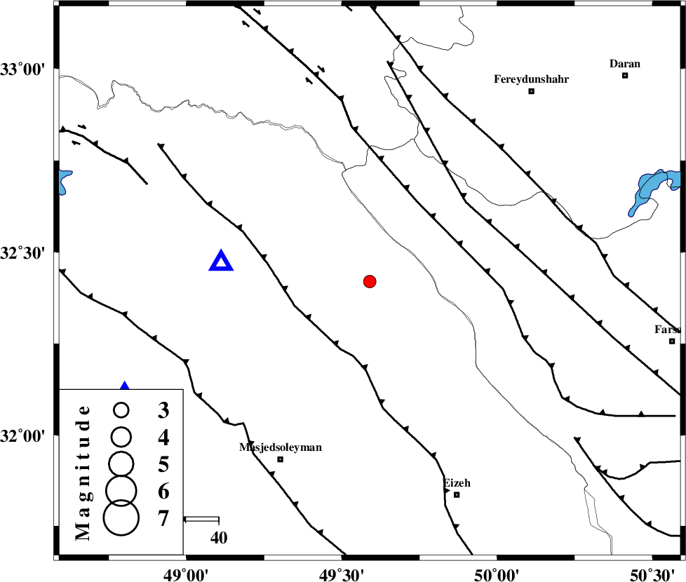
| Location | Lat:32.42 Lon: 49.59 |
| Region | Khoozestan Province, 46 km East of Lali |
Nearest Cities |
|
| 15 km North of Paabshalal, Khoozestan Province | |
| 28 km North East of Qale-yekhvaju, Khoozestan Province | |
| 40 km South West of Durak, Chaharmahal Bakhtiari Province | |
| 45 km North East of Lali, Khoozestan Province | |
| 47 km North East of Jaefarabad, Khoozestan Province | |
| Depth | 42 km |
| Agency | |
Faults within 150 km: |
|
| MFF2 (Length: 205 km) , Distance to epicenter: 22 km | |
| ZARDKUH_F (Length: 139 km) , Distance to epicenter: 28 km | |
| ARDAL_F (Length: 170 km) , Distance to epicenter: 38 km | |
| Number of Phases | 4 |
| RMS | 0 |
| Number of Stations | 3 |
| Error in Latitude | >1.8 km |
| Error in Longitude | 4 km |
| Error in Depth | 3.9 km |
Download waveform in seisan format
to download seisan software Click here
to access information about IIEES stations Click here
Amplitude | ||||||||
| UID | Agency | Station | Component | Amplitude | Period | Arrival Time | Proccessing Time | Signal Clip |
| 59606 | IIEES | SHGR | N | 254.6 | 0.27 | 2009-12-26 05:50:52 | 2010-02-08 11:55:00 | n |
| 59607 | IIEES | SHGR | E | 174.1 | 0.22 | 2009-12-26 05:50:53 | 2010-02-08 11:55:00 | n |
| 59608 | IIEES | ASAO | N | 22 | 0.68 | 2009-12-26 05:51:31 | 2010-02-08 11:55:00 | n |
Phase | ||||||||||||
| Agency | Station | Component | Phase Type | Phase Quality | First Motion | Observed Arrival Time | Time Residual | Loc. Flag | Input Weight | Distance | Azimuth | |
| IIEES | SHGR | Z | Pg | E | 2009-12-26 05:50:36 | 0 | y | 82.4 | 245 | |||
| IIEES | ASAO | Z | Pn | E | 2009-12-26 05:50:56 | 0 | y | 239 | 10 | |||
| IIEES | ASAO | N | Sg | E | 2009-12-26 05:51:28 | 0 | y | 239 | 10 | |||
| IIEES | NASN | Z | Pn | E | 2009-12-26 05:51:05 | 0 | y | 305 | 81 | |||