
Magnitude |
:2.6 |
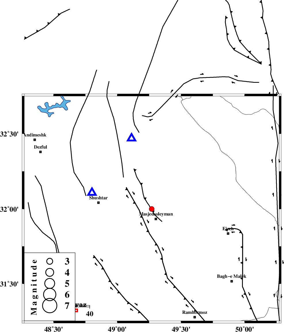
| Date & Time (UTC) | 2009-12-22 16:55:02.5 |
| Date & Time (Local) | 1388/10/1 20:25:02.5 |
| Location | Lat:32 Lon: 49.27 |
| Region | Khoozestan Province, 8 km Masjed Soleyman |
Nearest Cities |
|
| 8 km North of Masjed Soleyman, Khoozestan Province | |
| 24 km South East of Haft shahidan, Khoozestan Province | |
| 28 km South West of Qale-yekhvaju, Khoozestan Province | |
| 33 km South East of Jaefarabad, Khoozestan Province | |
| 40 km East of Shushtar, Khoozestan Province | |
| Depth | 14 km |
| Agency | |
Faults within 150 km: |
|
| DEZFUL_EMBAYMENT (Length: 228 km) , Distance to epicenter: 7 km | |
| MFF2 (Length: 205 km) , Distance to epicenter: 34 km | |
| ZARDKUH_F (Length: 139 km) , Distance to epicenter: 82 km | |
| Number of Phases | 6 |
| RMS | 0.4 |
| Number of Stations | 5 |
| Error in Latitude | >9.3 km |
| Error in Longitude | 8.6 km |
| Error in Depth | 13.5 km |
Download waveform in seisan format
to download seisan software Click here
to access information about IIEES stations Click here
Amplitude | ||||||||
| UID | Agency | Station | Component | Amplitude | Period | Arrival Time | Proccessing Time | Signal Clip |
| 59549 | IIEES | SHGR | E | 618.3 | 0.72 | 2009-12-22 16:55:23 | 2010-02-08 11:55:00 | n |
| 59550 | IIEES | SHGR | N | 447.8 | 0.52 | 2009-12-22 16:55:29 | 2010-02-08 11:55:00 | n |
| 59551 | IIEES | KHMZ | E | 45.1 | 0.56 | 2009-12-22 16:56:11 | 2010-02-08 11:55:00 | n |
| 59552 | IIEES | ASAO | E | 21.6 | 0.64 | 2009-12-22 16:56:34 | 2010-02-08 11:55:00 | n |
Phase | ||||||||||||
| Agency | Station | Component | Phase Type | Phase Quality | First Motion | Observed Arrival Time | Time Residual | Loc. Flag | Input Weight | Distance | Azimuth | |
| IIEES | SHGR | Z | Pg | E | 2009-12-22 16:55:10 | 0.1 | y | 46 | 285 | |||
| IIEES | KHMZ | Z | Pg | E | 2009-12-22 16:55:35 | -0.5 | y | 203 | 18 | |||
| IIEES | KHMZ | N | Sg | E | 2009-12-22 16:56:00 | 0.1 | y | 203 | 18 | |||
| IIEES | ASAO | Z | Pn | E | 2009-12-22 16:55:47 | 0.7 | y | 291 | 14 | |||
| IIEES | NASN | Z | Pn | E | 2009-12-22 16:55:53 | -0.1 | y | 344 | 74 | |||
| IIEES | SNGE | Z | Pn | E | 2009-12-22 16:55:58 | -0.4 | y | 387 | 333 | |||