
Magnitude |
:2.5 |
| Date & Time (UTC) | 2009-12-13 15:58:23.5 |
| Date & Time (Local) | 1388/9/22 19:28:23.5 |
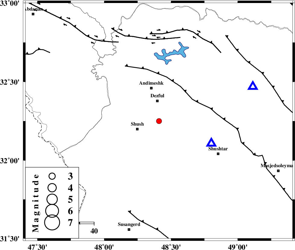
| Location | Lat:32.25 Lon: 48.41 |
| Region | Khoozestan Province, 15 km South of Dezful |
Nearest Cities |
|
| 6 km of Shamsabad, Khoozestan Province | |
| 14 km South of Dezful, Khoozestan Province | |
| 15 km North East of Amaleh teimur, Khoozestan Province | |
| 16 km North East of Shush, Khoozestan Province | |
| 24 km South of Andimeshk, Khoozestan Province | |
| Depth | 45 km |
| Agency | |
Faults within 150 km: |
|
| DEZFUL_EMBAYMENT (Length: 228 km) , Distance to epicenter: 28 km | |
| BALARUD_F_Z3 (Length: 53 km) , Distance to epicenter: 58 km | |
| BALARUD_F_Z2 (Length: 58 km) , Distance to epicenter: 62 km | |
| Number of Phases | 6 |
| RMS | 0.1 |
| Number of Stations | 4 |
| Error in Latitude | >2.1 km |
| Error in Longitude | 4.2 km |
| Error in Depth | 2.8 km |
Download waveform in seisan format
to download seisan software Click here
to access information about IIEES stations Click here
Amplitude | ||||||||
| UID | Agency | Station | Component | Amplitude | Period | Arrival Time | Proccessing Time | Signal Clip |
| 59499 | IIEES | SHGR | E | 336 | 0.56 | 2009-12-13 15:58:41 | 2010-02-08 11:55:00 | n |
| 59500 | IIEES | SHGR | N | 321.8 | 0.28 | 2009-12-13 15:58:50 | 2010-02-08 11:55:00 | n |
| 59501 | IIEES | KHMZ | N | 39.9 | 0.4 | 2009-12-13 15:59:26 | 2010-02-08 11:55:00 | n |
| 59502 | IIEES | KHMZ | E | 21.9 | 0.4 | 2009-12-13 15:59:33 | 2010-02-08 11:55:00 | n |
| 59503 | IIEES | ASAO | N | 18.4 | 0.56 | 2009-12-13 15:59:49 | 2010-02-08 11:55:00 | n |
| 59504 | IIEES | ASAO | E | 16.2 | 0.48 | 2009-12-13 15:59:53 | 2010-02-08 11:55:00 | n |
Phase | ||||||||||||
| Agency | Station | Component | Phase Type | Phase Quality | First Motion | Observed Arrival Time | Time Residual | Loc. Flag | Input Weight | Distance | Azimuth | |
| IIEES | SHGR | Z | Pg | E | 2009-12-13 15:58:33 | 0 | y | 40.1 | 113 | |||
| IIEES | KHMZ | Z | Pn | E | 2009-12-13 15:58:55 | 0 | y | 220 | 41 | |||
| IIEES | KHMZ | E | Sg | E | 2009-12-13 15:59:25 | 0.1 | y | 220 | 41 | |||
| IIEES | ASAO | Z | Pn | E | 2009-12-13 15:59:05 | 0 | y | 296 | 30 | |||
| IIEES | ASAO | E | Sg | E | 2009-12-13 15:59:45 | -0.1 | y | 296 | 30 | |||
| IIEES | SNGE | Z | Pn | E | 2009-12-13 15:59:09 | 0 | y | 330 | 343 | |||