
Magnitude |
:3.9 |
| Date & Time (UTC) | 2009-12-13 03:50:34.0 |
| Date & Time (Local) | 1388/9/22 07:20:34.0 |
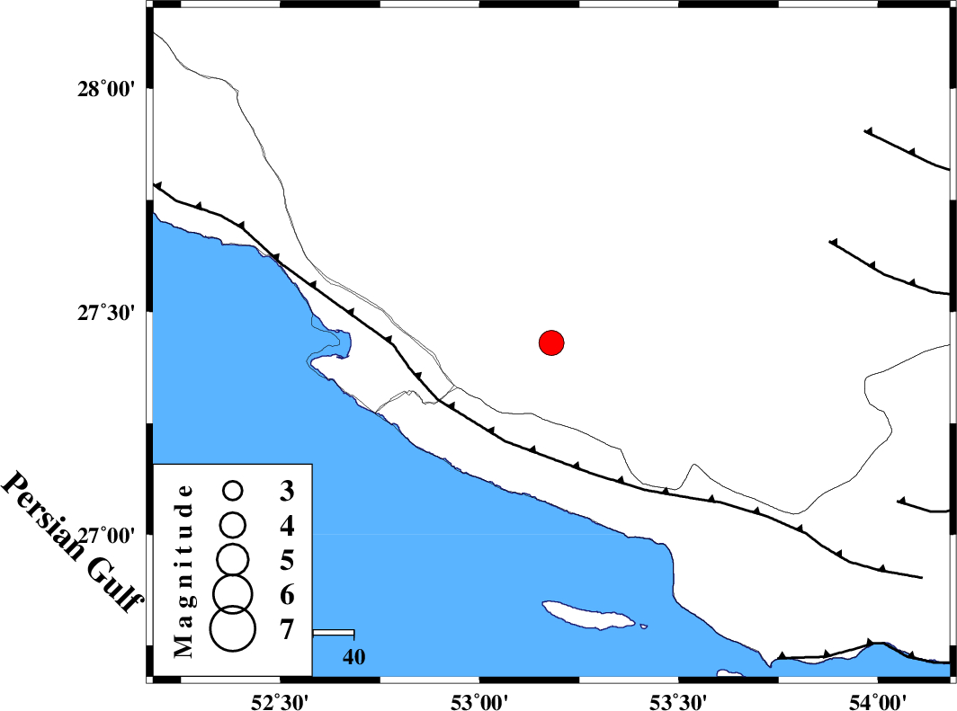
| Location | Lat:27.43 Lon: 53.18 |
| Region | Fars Province, 10 km Lamerd |
Nearest Cities |
|
| 11 km North of Lamerd, Fars Province | |
| 20 km East of Khoozi, Fars Province | |
| 30 km South East of Alamarvdasht, Fars Province | |
| 32 km South East of Mehr, Fars Province | |
| 33 km North West of Beyram, Fars Province | |
| Depth | 26 km |
| Agency | |
Faults within 150 km: |
|
| MFF3 (Length: 292 km) , Distance to epicenter: 27 km | |
| LAR_F (Length: 99 km) , Distance to epicenter: 73 km | |
| QIR_F (Length: 130 km) , Distance to epicenter: 93 km | |
| Number of Phases | 4 |
| RMS | 0 |
| Number of Stations | 3 |
| Error in Latitude | >5.2 km |
| Error in Longitude | 5.6 km |
| Error in Depth | 6.2 km |
Download waveform in seisan format
to download seisan software Click here
to access information about IIEES stations Click here
Amplitude | ||||||||
| UID | Agency | Station | Component | Amplitude | Period | Arrival Time | Proccessing Time | Signal Clip |
| 59489 | IIEES | GHIR | E | 5170.4 | 0.45 | 2009-12-13 03:51:08 | 2010-02-08 11:55:00 | n |
| 59490 | IIEES | GHIR | N | 5566.7 | 0.41 | 2009-12-13 03:51:10 | 2010-02-08 11:55:00 | n |
| 59491 | IIEES | KRBR | N | 91.3 | 0.61 | 2009-12-13 03:52:29 | 2010-02-08 11:55:00 | n |
| 59492 | IIEES | KRBR | E | 111 | 0.49 | 2009-12-13 03:52:53 | 2010-02-08 11:55:00 | n |
Phase | ||||||||||||
| Agency | Station | Component | Phase Type | Phase Quality | First Motion | Observed Arrival Time | Time Residual | Loc. Flag | Input Weight | Distance | Azimuth | |
| IIEES | GHIR | Z | Pg | E | 2009-12-13 03:50:50 | 0 | y | 97.3 | 349 | |||
| IIEES | GHIR | E | Sg | E | 2009-12-13 03:51:02 | 0 | y | 97.3 | 349 | |||
| IIEES | KRBR | Z | Pn | E | 2009-12-13 03:51:36 | 0 | y | 450 | 50 | |||
| IIEES | KHMZ | Z | Pn | E | 2009-12-13 03:52:15 | 0 | y | 765 | 337 | |||